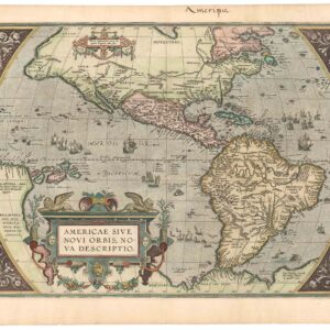
A fine original black-and-white example of the first printed folio map of North America.
Americae Pars Borealis, Florida, Baccalaos, Canada, Corterealis. A Cornelio de Iudaeis in luce edita.
Out of stock
Description
Key points:
1. Cornelius de Jode’s 1593 “America Pars Borealis” encapsulates the European understanding of North America only a century after the voyages of Christopher Columbus.
2. With its singular focus on North America and its extensive notes, De Jode’s map has no contemporary equal. But more than that, it gives us a window into the compiling process of a cartographer working in a time of constant change.
3. The list of firsts or near firsts associated with this map is long and impressive: besides being the first printed folio map of North America, it makes one of the first references to the Apache Tribe, it is one of the first maps of the continent to name Virginia and the settlement of St. Augustine, to associate ‘Appalachian’ with the mountain range, and many more.
This rare and well-preserved 1593 map of North America by Cornelis de Jode is one of the most significant early depictions of the continent. Created over a century after Columbus’ arrival, it embodies the rapid expansion of European exploration and the competitive spirit of 16th-century cartographers. Published in Speculum Orbis Terrae, a revised edition of his father’s atlas, the map reflects both advancements and errors in geographic knowledge of the time. Despite its exceptional quality, De Jode’s work struggled to compete with Abraham Ortelius’ popular atlas, leading to its limited circulation and rarity today.
Cartographic Influence and Sources
This map represents a pivotal moment in cartography, blending tradition and innovation to provide the most accurate possible depiction of North America. While it builds on earlier Italian efforts—particularly Paolo Forlani and Bolognino Zaltieri’s 1565 map—De Jode’s chart is far more detailed, incorporating insights from Petrus Plancius’ 1592 map and Theodor de Bry’s maps of Virginia and Florida (1590-91). However, errors remain, such as a 5° northern deviation along the East Coast, misplacing Chesapeake Bay at the latitude of New Hampshire—a consequence of merging French and English reports that conflicted in their claims.
As European powers vied for dominance, maps became strategic tools in legitimizing territorial ambitions. De Jode condensed the Maine-to-Virginia coastline into a compact stretch, omitting key features like Cape Cod and Long Island while incorporating Giovanni da Verrazzano’s and Walter Raleigh’s discoveries.
Depictions and Features
Northern Regions and the Search for the Northwest Passage
A prominent Northwest Passage dominates the upper section, reflecting the persistent European dream of a direct route to Asia. The passage flows from a strait between Greenland and Labrador, leading into a vast bay, possibly an early rendition of Hudson Bay. Further north, an ‘INCÓGNITA’ landmass features mountain ranges, based more on speculation than actual reports.
Notably, De Jode references the 1470s Danish-Portuguese expedition of John Scolvus and Joao Vaz Corte-Real, which some believe reached Newfoundland before Columbus. While modern historians debate the accuracy of this claim, De Jode’s reliance on these sources suggests their significant influence on 16th-century cartographers.
New France and the St. Lawrence River
The French presence is strongly emphasized, with ‘NOVA FRANCIA’ labeled prominently. The St. Lawrence River extends deep into the continent, nearly reaching modern Texas, hinting at an imagined transcontinental passage. The Iroquois settlement of Hochalaga (Montreal’s precursor) is depicted, referencing Jacques Cartier’s 1535 visit, though by the late 16th century, the site had been abandoned due to disease and conflict.
Mythical and Misinterpreted Geographies
The map incorporates enduring cartographic myths, including:
- Lake Conibas, a fictitious northern freshwater lake, widely depicted in early American maps.
- The Seven Cities of Cibola, a legendary land of gold, drawn from the embellished reports of Marcos de Niza (1539).
- California as a Peninsula, an accurate depiction preceding its later misrepresentation as an island.
The Gulf of Mexico and Early Spanish Expeditions
De Jode’s detailed Gulf of Mexico coastline incorporates data from Spanish explorations, including:
- Ponce de León’s 1513 Florida expedition, with Charlotte Harbor labeled Sinus Ioannes Ponce.
- Hernando de Soto’s travels, reflected in an early depiction of the Mississippi River (‘R. de S. Spirito’), remarkably accurate for its time.
Virginia and English Colonization
De Jode’s map is one of the first general maps to label ‘Virginia’, reflecting early English colonial ambitions. A detailed inscription about Raleigh’s 1585 Roanoke settlement highlights the region’s natural wealth and strategic potential. This passage—emphasizing resources, law-abiding inhabitants, and opportunity—reads like an invitation for colonization, foreshadowing the Dutch and English expansion in the New World.
A fascinating inset in the lower-right corner illustrates six Native American figures, likely drawn from John White’s Roanoke sketches. This imagery, alongside annotations about tribes in the Appalachian region, showcases De Jode’s effort to integrate ethnographic details.
Greenland, Iceland, and the Phantom Island of Frisland
De Jode correctly places Greenland and Iceland (Thule) but includes the mythical island of Frisland, a persistent cartographic error stemming from Nicolò Zeno’s 1558 forgery, which many contemporary mapmakers accepted as fact.
Context and Legacy
Cornelis de Jode’s Speculum Orbis Terrae (1593) emerged during a transformative era in cartography, shifting away from Ptolemaic tradition toward a more empirical and observational approach. However, despite its quality, his atlas struggled commercially, overshadowed by Ortelius’ Theatrum Orbis Terrarum. After De Jode’s death, Antwerp publisher Jan Baptiste Vrients acquired and later destroyed the plates, ensuring no further printings—a factor contributing to the rarity of De Jode maps today.
This map encapsulates 16th-century European exploration, imperial ambition, and evolving geographic knowledge, marking both the height of Renaissance cartography and the dawn of a new era of colonial expansion.
Cartographer(s):
Gerard de Jode (1511–91) was a Dutch printer and mapmaker born in Nijmegen who worked from Antwerp, then the center of European cartographic production. Accepted into the Guild of St. Luke in 1547, he quickly earned a reputation as a skilled mapmaker — though his business acumen never quite matched his cartographic talent. His greatest achievement was the two-volume Speculum Orbis Terrarum (1578), conceived as a rival to Ortelius’ enormously popular Theatrum Orbis Terrarum. Despite De Jode’s reputation, the atlas sold poorly — a commercial failure whose consequence is that barely a dozen copies survive today, making it one of the rarest atlases in existence.
Undeterred, De Jode began work on a revised and expanded atlas with his son Cornelis (1568–1600). The result, Speculum Orbis Terrae (1593), retained Gerard’s original maps while incorporating significant revisions and new maps compiled by Cornelis. Gerard died two years before publication. The atlas fared no better commercially, and after Cornelis’ death the plates were sold to J. B. Vrients — who also owned the Ortelius plates — effectively ensuring the work would never be reprinted. Where Ortelius ran to dozens of editions, the De Jode atlas exists only in its two original editions of 1578 and 1593.
Condition Description
Very good. Crisp black and white.
References
Burden, Philip D. The Mapping of North America. Raleigh Publications, 2018, 81.
Hayes, Derek. Historical Atlas of California: with Original Maps. Vancouver: Douglas & McIntyre, 2007.
Kerr, Robert. A General History of Voyages and Travels to the End of the 18th Century, Volume 6. Edinburgh: J. Ballantyne & Co., 1811.