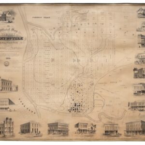
Though best remembered as a naval officer, explorer, and naturalist, Charles M. Scammon also played a brief but notable role in early California cartography. Born in Pittston, Maine, Scammon came to California in 1849 as part of the Gold Rush, eventually joining the U.S. Coast Survey and working along the Pacific coast as a hydrographer and draughtsman. In the early 1850s, he participated in civil and harbor surveys throughout Northern California, producing several important manuscript and printed maps for local governments and land speculators, including the Official Map of the City of Marysville (1856), compiled with A. Boardman. His training in coastal navigation and topographic drafting lent the Marysville plan its unusually high level of technical precision.
After his surveying period, Scammon entered the whaling industry, where he achieved fame for discovering and charting the breeding lagoons of the gray whale on the Baja California coast—a feat that later informed his classic natural history The Marine Mammals of the North-Western Coast of North America (1874). Though his cartographic career was brief, his Marysville map remains one of the finest examples of mid-century urban surveying in Gold Rush California.
Archived
- Out of Stock
- California
Official Map of the City of Marysville, California. Compiled by N. Wescoatt, City Surveyor, and W. S. Watson, Civil Engineer, from Recent Surveys by N. Wescoatt.
- An exceptional and monumental Gold Rush-era city plan of one of early California’s most prosperous river ports at its peak.
- Read moreQuick View
-