Edward C. Prather (1872–1938) was a mapmaker and surveyor active in early 20th–century California. Specializing in detailed land surveys, Prather was critical in planning and developing the Bay Area’s emerging cities. His precise maps and innovative measurement techniques provided reliable data for urban planners and developers during rapid growth. Among the surveyed urban development projects are the Crocker Highlands developments, Peralta Heights, and Thermal Hill inside Oakland. He also worked extensively on projects in and around Alameda, including Elmhurst, the Brooklyn Township, and Pleasanton.
Prather’s work was marked by technical accuracy and the latest surveying methods, allowing his maps to become highly collectible historical records of Northern California’s evolving landscapes.
-
-
Add to cart
 Quick View
 - Bay Area & Silicon Valley, California
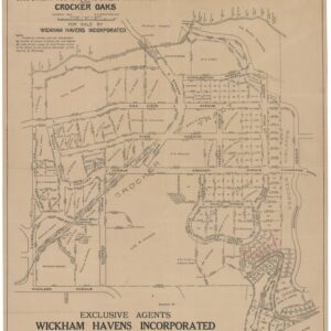
Properties in Crocker Tracts, Crocker Terrace and Crocker Oaks.
- $650
- Edward Prather’s 1914 cadastral map of the Crocker Highlands development in Oakland.
-
-