Giacomo Cantelli da Vignola (1643–1695) was a prominent Italian cartographer known for his detailed and decorative maps, which significantly contributed to the field of cartography in the 17th century. Born in Vignola, near Modena, Italy, little is known about his early life and education. Cantelli began his cartographic career in the late 17th century, a period marked by increasing sophistication and artistry in mapmaking. He was renowned for his maps’ accuracy and intricate details, often embellished with elaborate cartouches and mythical figures, making them both practical and aesthetically pleasing.
Cantelli produced numerous maps covering various regions of Europe, Asia, and Africa, many of which were included in atlases published by prominent publishers such as Giovanni Giacomo De Rossi in Rome. His maps of Italy, the Balkans, and the Mediterranean region were particularly well-regarded for their precision and detail. Cantelli’s collaboration with De Rossi helped disseminate his work widely, establishing his reputation as a leading cartographer of his time.
Cantelli’s influence on cartography extended beyond his lifetime, setting a standard for mapmaking in the late 17th and early 18th centuries. His combination of artistic elements with geographical accuracy was admired and emulated by other cartographers. Today, Cantelli’s maps are valuable historical documents preserved in libraries, museums, and private collections worldwide, providing insights into the geographical knowledge and artistic sensibilities of the 17th century. Giacomo Cantelli da Vignola remains a significant figure in the history of cartography, remembered for his meticulous and beautifully crafted maps that advanced geographical knowledge during his era.
-
-
Add to cart
 Quick View
 - Europe, Italy
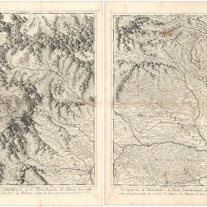
Il Ducato d’Ausfa, il Canavese, et il Marchesato di Susa… / La Signoria di Vercelli, e la Parte Settentrionale del Monferrato…
- $675
- A superb pair of Baroque maps of Piedmont and the Western Alps.
-
-
-
-
Add to cart
![Dalmatia maritima [2 sheets].](https://neatlinemaps.com/wp-content/uploads/2024/08/NL-02219-merged_thumbnail-300x300.jpg) Quick View
Quick View - Europe, Greece & the Balkans, Italy
Dalmatia maritima [2 sheets].
- $1,200
- The De Rossi-Cantelli two-sheet map of the Dalmatian coast.
-
-
Archived
- Out of Stock
- Europe, France & Switzerland
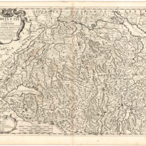
L’Helvetia o’ Paese de Suizzeri…
- A fine 17th-century map of Switzerland and parts of Italy, including Lake Como.
- Read moreQuick View
-