Jules Hansen (1849-1931) was a Danish cartographer born in Paris, where he also studied surveying techniques and geography. In 1876, he became a member of the Societé de Géographie, which published many of his maps over the next two decades. Hansen had a particular focus on Africa, and within the framework of the Society, he gained unique insights into the great continent. He befriended members of the French Congo Expedition (1885), and in 1889, he was appointed the official cartographer for the French Ministry of the Colonies.
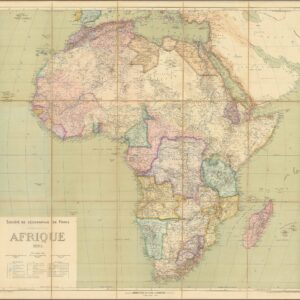
Among Hansen’s most remarkable cartographic achievements was mapping the Middle Niger River and the mysterious Upper Nile. He also issued a map of Madagascar, which included the routes taken by various French expeditions to explore the island. The most seminal achievement of Hansen’s career was nevertheless the publication of his grand Africa map at a scale of 1:10,000,000 in 1895. This map was a key document for French interests in the Scramble for Africa and was updated yearly until 1899 to incorporate the latest discoveries and political developments.
Archived
- Out of Stock
- Africa
Société de Géographie de Paris AFRIQUE 1895
- Jules Hansen’s seminal map of colonial Africa.
- Read moreQuick View
-