The Ordnance Survey was, and still is, the official National Mapping Agency in Great Britain. Founded in 1791 as the cartographic arm of the British Army, The Ordnance Survey was primarily responsible for mapping Great Britain itself. Yet as the British Empire expanded its holdings militarily, Ordnance Surveys were instigated at key locations throughout the world, often in collaboration with other governmental or semi-governmental bodies.
No products were found matching your selection.
Archived
- Out of Stock
![[Two maps sold together] The First Ordnance Surveys of Jerusalem. By Captain Charles W. Wilson R.E. Under The Direction of Colonel Sir Henry James, R.E. F.R.S. & C. Director of the Ordnance Survey. 1864-5.](https://neatlinemaps.com/wp-content/uploads/2023/03/NL-01527_thumbnail-300x300.jpg)
- Eastern Mediterranean - Holy Land
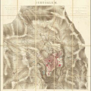
[Two maps sold together] The First Ordnance Surveys of Jerusalem. By Captain Charles W. Wilson R.E. Under The Direction of Colonel Sir Henry James, R.E. F.R.S. & C. Director of the Ordnance Survey. 1864-5.
- The British Ordnance Survey of 1864-65 was the first scientific attempt to map Jerusalem and its environs, a watershed survey that saw two of the finest Victorian maps ever created.
- Read moreQuick View
-
- Out of Stock
- Eastern Mediterranean - Holy Land
Ordnance Survey of Jerusalem. This Survey Was Made In The Years 1864-5 By Captain Charles W. Wilson R.E. and a Party of Royal Engineers From The Ordinance Survey. Under The Direction of Colonel Sir Henry James, R.E. F.R.S. & C. Director of the Ordnance Survey.
- The first Ordnance Survey of Jerusalem and environs.
- Read moreQuick View
-