-
-
Add to cart
 Quick View
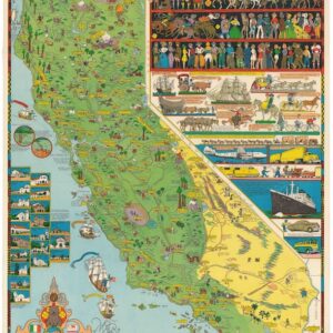
 - California, Pictorial maps
California.
- $1,600
- Jo Mora’s iconic 1945 map of California.
-
-
-
-
Add to cart
 Quick View
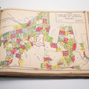
 - Bay Area & Silicon Valley, California
Thomas Bros Block Book of Burlingame and Hillsborough.
- $3,500
- Rare c. 1940 Thomas Bros. block book mapping Hillsborough and Burlingame’s elite Bay Area estates and landowners.
-
-
-
-
Add to cart
![Das Jahr der Kirche [The Year of the Church]](https://neatlinemaps.com/wp-content/uploads/2022/09/NL-01244_thumbnail-1-300x300.jpg)
![Das Jahr der Kirche [The Year of the Church]](https://neatlinemaps.com/wp-content/uploads/2022/09/NL-01244_thumbnail-scaled.jpg) Quick View
Quick View - Curiosities - Miscellanea
Das Jahr der Kirche [The Year of the Church]
- $475
- A large-format German liturgical calendar in the Medieval style.
-
-
![Das Jahr der Kirche [The Year of the Church]](https://neatlinemaps.com/wp-content/uploads/2022/09/NL-01244_thumbnail-scaled-300x300.jpg)
-
-
-
Add to cart
 Quick View
 - Atlases & Books, Canada and The Great Lakes, North America, United States
Joint maps of the northern boundary of the United States: from the Lake of the Woods to the summit of the Rocky Mountains.
- $500
- Defining the U.S.–Canadian border along the 49th parallel from the Lake of the Woods to the Rockies.
-
-
-
-
Add to cart
 Quick View
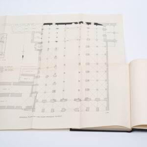
 - Atlases & Books, Eastern Mediterranean - Holy Land
The Structural History of the Aqsa Mosque. A record of archaeological gleanings from the repairs of 1938-1942.
- $12,500
- The only comprehensive architectural history of one of the world’s most important mosques.
-
-
-
-
Add to cart
 Quick View
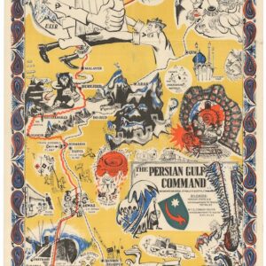
 - Iran - Persia - Central Asia, Middle East - Holy Land Maps, World War I and World War II
The Persian Gulf Command.
- $2,600
- Rare 1945 Allied propaganda map published in Tehran, vividly depicting the Persian Gulf Command’s vital WWII supply route through Iran to the Soviet Union.
-
-
-
-
Add to cart
 Quick View
 - Middle East - Holy Land Maps, Arabia and the Red Sea
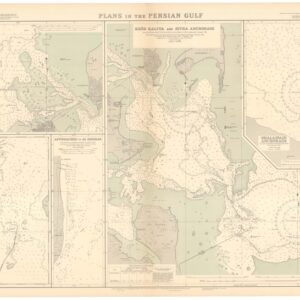
British Admiralty Chart No. 3789. Plans in the Persian Gulf.
- $2,400
- A British Admiralty map of the Persian Gulf, created at the dawn of Arabia’s emergent oil industry.
-
-
-
-
Add to cart
 Quick View
 - Americas, North America, United States
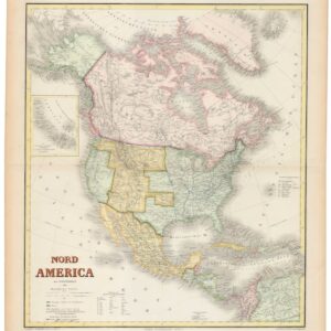
Nord America mit Westindien.
- $975
- Hand-colored ca. 1867 Kiepert map of North America, capturing the post-Civil War U.S., shifting Canadian and Mexican frontiers, and colonial Caribbean.
-
-
-
-
Add to cart
![PORT OF SAN FRANCISCO. WHERE THE FAR EAST BEGINS [Japanese language version]](https://neatlinemaps.com/wp-content/uploads/2021/01/NL-00879_Thumbnail-300x300.jpg)
![PORT OF SAN FRANCISCO. WHERE THE FAR EAST BEGINS [Japanese language version]](https://neatlinemaps.com/wp-content/uploads/2021/01/NL-00879_Thumbnail.jpg) Quick View
Quick View - Bird's-eye-views, San Francisco
PORT OF SAN FRANCISCO. WHERE THE FAR EAST BEGINS [Japanese language version]
- $475
- Rare Japanese language bird's-eye-view in the style of Saul Steinberg showing the port of San Francisco as the gateway to Pacific commerce.
-
-
-
-
-
Add to cart
 Quick View
 - Asia, Southeast Asia & Australia
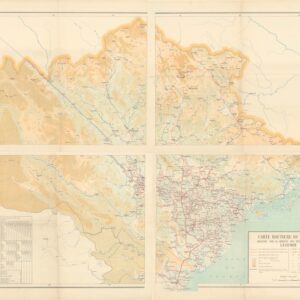
Carte Routiere du Tonkin.
- $1,800
- Massive 4-sheet 1923 French colonial map of Tonkin illustrating the evolving French road and rail network in northern Vietnam.
-
-
-
-
Add to cart

 Quick View
 - Africa, Arabia and the Red Sea, Asia
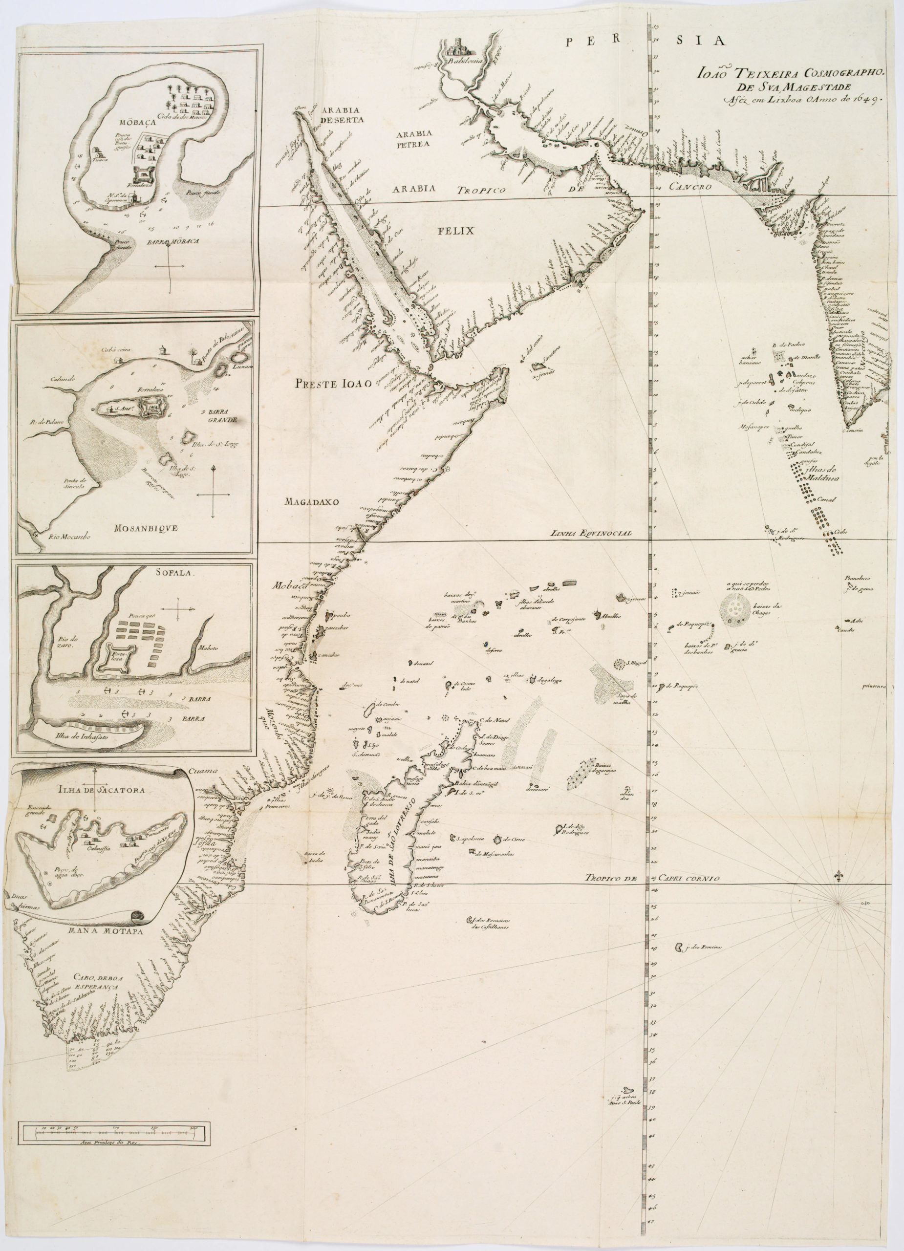
João Teixeira Cosmographo. De sua, Magestade. Aféz em Lixboa o Anno de 1649
- $4,200
- Rare 17th century portolan-style chart designed for use aboard Portuguese merchant vessels.
-
-
-
-
-
Add to cart
 Quick View
 - Atlases & Books, California, Texas and The West
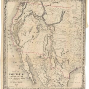
Map of California, Oregon, Texas, and the territories adjoining, with routes &c.
- $1,900
- Colton’s iconic map of the West, with California Gold region and extended Texas borders.
-
-