-
-
Add to cartQuick View
- Texas and The West, East & Midwest United States
Carte De La Louisiane Et Du Cours Du Mississipi Avec Les Colonies Anglaises.
- $1,200
- Dezauche's 1782 map of colonial America: a map that blends Delisle's celebrated achievements with new features for the Revolutionary War.
-
Add to cart
-
-
Add to cartQuick View
- Texas and The West
County Map of Texas.
- $450
- A fascinating post-Civil War map of Texas.
-
Add to cart
-
-
Add to cartQuick View
- Texas and The West, Railroad Maps
Maps of the New and Popular St. Louis and Texas Short Line!
- $1,800
- An eye-catching 1878 broadside inviting people to come and settle in Texas; a state in which a formal civilian government had only been restored eight years earlier.
-
Add to cart
-
-
Add to cartQuick View
- Texas and The West
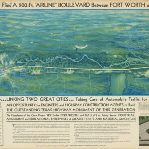
“As the Crow Flies” A 200-Ft. “Airline” Boulevard Between Fort Worth and Dallas
- $2,900
- A highly artistic broadside for the visionary Dallas-Fort Worth Airline Boulevard: a Depression-era infrastructure project designed to bridge and unite two Texas cities.
-
Add to cart
-
-
Add to cartQuick View
- Texas and The West
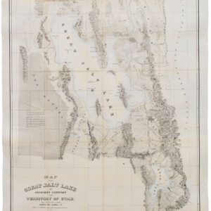
Map of the Great Salt Lake And Adjacent Country in the Territory Of Utah. Surveyed in 1849 and 1850…
- $850
- "Scientific cartography of the Territory of Utah may be said to date from the appearance of this map." - Wheat
-
Add to cart