-
-
Add to cart
![[Central Valley Agricultural Photo Album].](https://neatlinemaps.com/wp-content/uploads/2025/02/NL-02294-1_thumbnail-300x300.jpg) Quick View
Quick View - California
[Central Valley Agricultural Photo Album].
- $1,400
- A unique collection of early 20th-century photographs of the Central Valley.
-
-
-
-
Add to cart
 Quick View
 - California, San Francisco
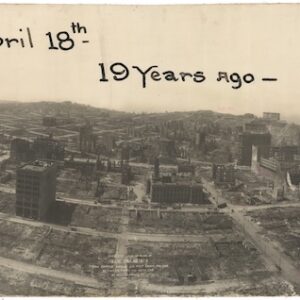
Bird’s-eye-view of ruins of San Francisco from captive airship, 600 feet above Folsom between Fifth and Sixth Sts.
- $2,400
- Large, dramatic panoramic photograph surveying the devastation of the 1906 San Francisco earthquake and fire.
-
-
-
-
Add to cart
 Quick View
 - Pacific Northwest - Hawaii - Alaska
Mount St. Helen’s Quadrangle (7.5 Minute Series)
- $575
- Washington’s dramatic volcanic peak, taken a few years before the catastrophic 1980 eruption.
-
-
-
-
Add to cart
 Quick View
 - Americas, Cuba, West Indies, Caribbean
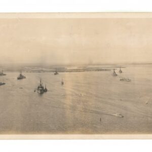
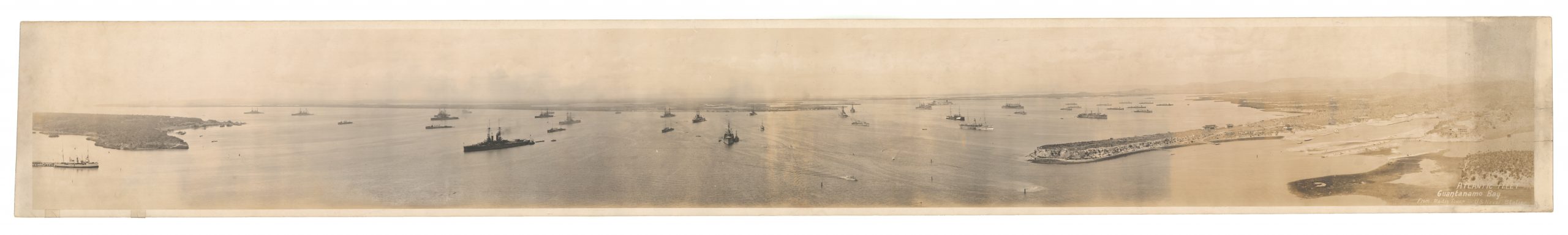
Atlantic Fleet. Guantanamo Bay from Radio Tower – U.S. Naval Station
- $800
- An evocative WW1 panoramic photograph of the U.S. Navy’s Atlantic Fleet stationed at their new base in Guantanamo Bay, Cuba.
-
-
-
-
-
Add to cart
![[Venice Lithographs].](https://neatlinemaps.com/wp-content/uploads/2024/10/NL-02277_thumbnail-300x300.jpg) Quick View
Quick View - Europe, Italy
[Venice Lithographs].
- $2,000
- An unusual set of late-19th-century photographic lithographs of Venice.
-
-
-
-
Add to cart
![[Forty-four photographs of shipbuilding in Oakland, California, 1918-1919.]](https://neatlinemaps.com/wp-content/uploads/2024/05/NL-01826-3_thumbnail-300x300.jpg) Quick View
Quick View - Bay Area & Silicon Valley, California
[Forty-four photographs of shipbuilding in Oakland, California, 1918-1919.]
- $925
- A unique collection of photographs documenting World War I shipbuilding activities at Oakland Harbor.
-
-
-
-
Add to cart
 Quick View
 - California, San Francisco, Atlases & Books
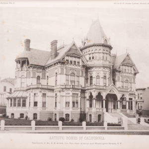
Artistic Homes of California.
- $12,500
- The most extensive collection of pre-1906 Bay Area architectural masterpieces.
-
-
-
-
Add to cart
 Quick View
 - Bird's-eye-views, Eastern Mediterranean - Holy Land
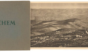
Bethlehem.
- $575
- Early 20th-century panoramic photo showing Bethlehem and its surroundings.
-
-
-
-
Add to cart
 Quick View
 - Bay Area & Silicon Valley, California
Album of photographs of commercial and residential properties in Berkeley, California.
- $1,250
- A fascinating documentation of Berkeley in the 1930s.
-
-
-
-
Add to cart
![[Morenci, Arizona Photograph Album]](https://neatlinemaps.com/wp-content/uploads/2024/05/NL-01915_thumbnail-300x300.jpg) Quick View
Quick View - Texas and The West
[Morenci, Arizona Photograph Album]
- $1,800
- An unrecorded early 20th-century photo album of mining operations in Arizona.
-
-
-
-
Add to cart
 Quick View
 - California
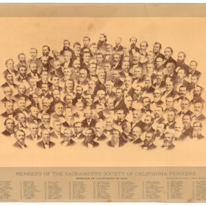
Members of the Sacramento Society of California Pioneers. Arrived in California in 1849.
- $900
- Group portrait of Sacramento’s ‘founding fathers,’ compiled by one of California’s pioneer photographers.
-
-
-
-
Add to cart
 Quick View
 - Curiosities - Miscellanea
164 Red No. photographs of BUSS (Balloon-born Ultraviolet Stellar Spectrometer) mission.
- $4,500
- A unique suite of 164 NASA ‘Red Numbered Photographs’ documenting one of the most pioneering space missions in the 1970s.
-
-