1850 Map of Asia Minor, Covering Anatolia, Syria, Mesopotamia, and the Levant.
Karte von Klein Asien.
$150
1 in stock
Description
The Ottoman Empire’s Heartland Three Years Before the Crimean War.
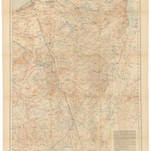
This is sheet 32 from Meyer’s Grosser Zeitungs-Atlas, drawn by Captain Carl Radefeld in 1850 and published by the Bibliographisches Institut in Hildburghausen. It covers Asia Minor and the surrounding region in a single commanding composition, from the Aegean coast of Anatolia in the west to the Tigris and Euphrates in Mesopotamia and the shores of the Persian Gulf in the east, with Cyprus and the Levantine coast in the center and Egypt visible at the lower left.
The entire mapped territory, with the exception of Persia at the right margin, lay within the Ottoman Empire in 1850, and it was the fate of that empire, the sick man of Europe in Tsar Nicholas I’s famous phrase, that dominated European diplomatic attention at precisely the moment this map was drawn. Three years later, the Crimean War would begin.
The Map in Detail
Anatolia fills the upper portion of the sheet, its Aegean coastline and island-strewn approaches rendered in detail, with the Black Sea forming the northern boundary. The Levantine coast runs southward through Syria and Lebanon, with Aleppo and the major cities of the Syrian interior labeled. The Euphrates and Tigris rivers are traced clearly across the center and right of the map, their courses through Mesopotamia constituting the hydrographic spine of the eastern portion of the sheet. The Arabian desert opens across the lower center, with the Persian Gulf at the lower right and the Red Sea and Egyptian coast visible at the lower left.
Historical Context
In 1850, the Ottoman Empire retained nominal sovereignty over the entire region shown on this map, but that sovereignty was increasingly formal. The Tanzimat reforms, initiated in 1839, sought to modernize the imperial administration, but the empire’s structural weakness was evident to all European powers, and the question of what would happen when it finally collapsed had become the central problem of European diplomacy. Russia pressed southward toward Constantinople and the Straits; Britain and France sought to preserve the empire as a buffer against Russian expansion; Austria watched nervously from the northwest.
The Crimean War of 1853 to 1856, in which Britain and France allied with the Ottomans against Russia, was the first major eruption of this tension into open conflict. Mesopotamia, shown here as a thinly populated Ottoman province traversed by the ancient rivers, would become the focus of British strategic interest during and after the First World War, culminating in the creation of Iraq as a British mandate in 1920. Syria and Lebanon would become a French mandate.
Publication History and Census
This map was published as sheet 32 of Meyer’s Grosser Zeitungs-Atlas by the Bibliographisches Institut in Hildburghausen in 1850, with distribution through Amsterdam, Paris, and Philadelphia. Individual sheets are occasionally encountered as extracts from bound volumes.
Cartographer(s):
Joseph Meyer (May 9, 1796 – June 27, 1856) was a German businessman and publisher of maps and atlases. After an active early career in business, which included early investments in railways, Meyer founded the publishing house Bibliographisches Institut in Gotha in 1826, which moved to Hildburghausen two years later. Initially, the publisher focused on reliable sellers like Bibles and encyclopedias, but gradually moved into maps and atlases and became especially known for its ‘Meyer’s Groẞer Hand-Atlas.’ After Joseph’s death, his son continued the business and continued to find great success, moving to Leipzig in 1874, with periodic bumps in the road due to wars and economic crises. The company survived both world wars and was divided along with Germany, but after 1991 moved back to its original location in Leipzig. In 1984, the company merged with a competitor to form Bibliographisches Institut & F. A. Brockhaus AG, which survives today.
Condition Description
Very good. Minor chip in the bottom-left corner.
References