-
-
Add to cart
 Quick View
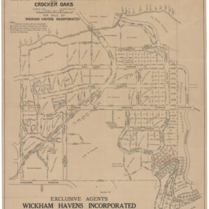
 - Bay Area & Silicon Valley, California
Properties in Crocker Tracts, Crocker Terrace and Crocker Oaks.
- $650
- Edward Prather’s 1914 cadastral map of the Crocker Highlands development in Oakland.
-
-
-
-
Add to cart
 Quick View
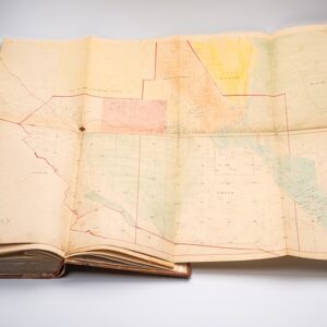
 - California, Bay Area & Silicon Valley, Atlases & Books
Assessment List Contra Costa County Sup. Dist. 2 Moraga Lafayette Walnut Creek & Alamo.
- $4,500
- Late 19th-century assessment with two fold-out maps, including a very early map of Walnut Creek.
-
-
-
-
Add to cart
 Quick View
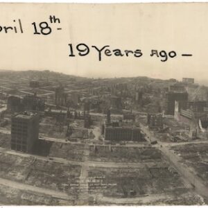
 - California, San Francisco
Bird’s-eye-view of ruins of San Francisco from captive airship, 600 feet above Folsom between Fifth and Sixth Sts.
- $2,400
- Large, dramatic panoramic photograph surveying the devastation of the 1906 San Francisco earthquake and fire.
-
-
-
-
Add to cart
 Quick View
 - Bay Area & Silicon Valley, California
Emeryville Industrial Tract.
- $400
- An early promotional map of Emeryville.
-
-
-
-
Add to cart
 Quick View
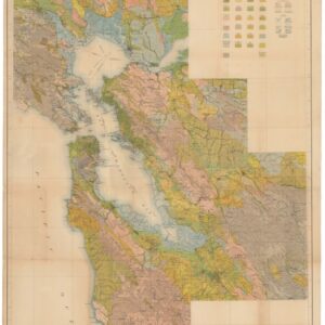
 - California, San Francisco
Soil Map. California. Reconnaisance Survey — San Francisco Bay Sheet.
- $750
- A massive 1914 San Francisco Bay Area Department of Agriculture Soil Map.
-
-
-
-
Add to cart
 Quick View
 - Americas, California, North America
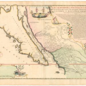
La Californie ou Nouvelle Caroline, Teatro De Los Trabajos Apostolicos De La Compa. E. Jesus En La America Septe…
- $7,500
- [Old Color] The largest cartographic depiction of the island of California ever made.
-
-
-
-
Add to cart
 Quick View
 - Pacific Northwest - Hawaii - Alaska
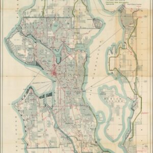
A Map for the City of Seattle and adjacent territory accompanying a report of MUNICIPAL PLANS COMMISSION.
- $1,200
- The famous ‘Bogue Plan’ of Seattle: an ambitious urban design for the city and environs from 1911.
-
-
-
-
Add to cart
![Carte De La Floride Occidentale et Louisiane…[with] La Peninnsule Et Golfe De La Floride ou Canal De Bahama Avec Les Isles De Bahama Traduit de Gefferys…1777.](https://neatlinemaps.com/wp-content/uploads/2025/01/NL-02329_thumbnail-300x300.jpg) Quick View
Quick View - East & Midwest United States
Carte De La Floride Occidentale et Louisiane…[with] La Peninnsule Et Golfe De La Floride ou Canal De Bahama Avec Les Isles De Bahama Traduit de Gefferys…1777.
- $2,800
- A scarce 1777 French map of Florida and the Gulf Coast.
-
-
-
-
Add to cart
![[Visitacion Valley SF] Abstract of Title and List of Incumbrances on Reis Tract part Visitacion Rancho.](https://neatlinemaps.com/wp-content/uploads/2025/01/NL-02325-cover_thumbnail-300x300.jpg) Quick View
Quick View - California, San Francisco
[Visitacion Valley SF] Abstract of Title and List of Incumbrances on Reis Tract part Visitacion Rancho.
- $650
- Rare Abstract of Title for San Francisco’s Reis Tract, with an early and uncertified cadastral map.
-
-
-
-
Add to cart
 Quick View
 - Europe
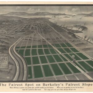
Boulevard Gardens. Quarter Acre Villa Lots.
- $1,200
- North Berkeley's Golden Past: a rare 1907 view of Boulevard Gardens.
-
-
-
-
Add to cart
 Quick View
 - Bay Area & Silicon Valley, California
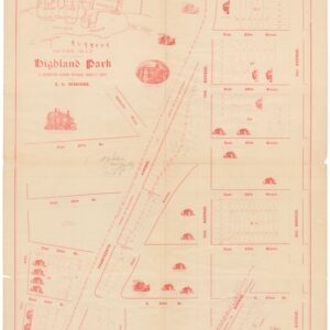
Highland Park.
- $475
- An 1893 Highland Park auction map with house vignettes.
-
-
-
-
Add to cart
 Quick View
 - Bay Area & Silicon Valley, California
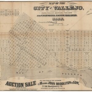
Map of the City of Vallejo, terminus of the Napa Valley, Sonoma Valley and California Pacific Railroad.
- $4,500
- The first official town plan of Vallejo.
-
-