-
-
Add to cart
 Quick View
 - Atlases & Books, Canada and The Great Lakes, North America, United States
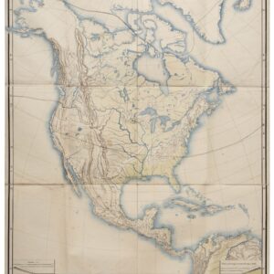
Reports upon the Survey of the Boundary between the Territory of the United States and the Possessions of Great Britain. Washington: Government Printing Office, 1878.
- $500
- 1878 U.S. report on the survey that fixed the U.S.–Canadian border along the 49th parallel.
-
-
-
-
Add to cart
 Quick View
 - Atlases & Books, Canada and The Great Lakes, North America, United States
Joint maps of the northern boundary of the United States: from the Lake of the Woods to the summit of the Rocky Mountains.
- $500
- Defining the U.S.–Canadian border along the 49th parallel from the Lake of the Woods to the Rockies.
-
-
-
-
Add to cart
 Quick View
 - Americas, North America, United States
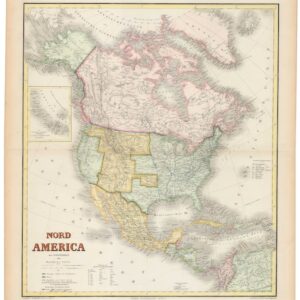
Nord America mit Westindien.
- $975
- Hand-colored ca. 1867 Kiepert map of North America, capturing the post-Civil War U.S., shifting Canadian and Mexican frontiers, and colonial Caribbean.
-
-
-
-
Add to cart
 Quick View
 - Americas, Featured Maps & Views, North America
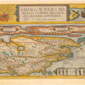
Americae Pars Borealis, Florida, Baccalaos, Canada, Corterealis. A Cornelio de Iudaeis in luce edita.
- $34,000
- The first printed folio map of North America and the most iconic American chart of the 16th century.
-
-
-
-
Add to cart
 Quick View
 - Americas, North America
General Charte von America nach dem besten hilfsmitteln.
- $450
- An unusual depiction of America's changing borders in the Jacksonian Era.
-
-
-
-
Add to cart
 Quick View
 - Americas, North America
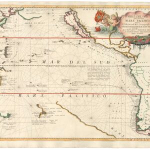
Mare Del Sud detto altrimenti Mare Pacifico.
- $2,500
- An excellent example of Coronelli's Pacific Ocean with California as an Island.
-
-
-
-
Add to cart
 Quick View
 - Americas, California, North America
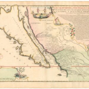
La Californie ou Nouvelle Caroline, Teatro De Los Trabajos Apostolicos De La Compa. E. Jesus En La America Septe…
- $7,500
- [Old Color] The largest cartographic depiction of the island of California ever made.
-
-
-
-
Add to cart
 Quick View
 - Americas, Cuba, West Indies, Caribbean, East & Midwest United States, North America
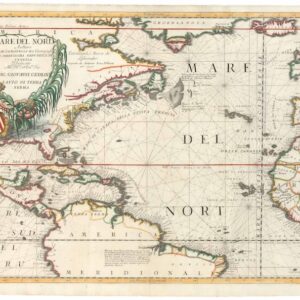
Mare del Nord.
- $2,200
- A gorgeous full-color example of Coronelli's chart of the Eastern Seaboard and North Atlantic.
-
-
-
-
Add to cart
 Quick View
 - Americas, Mexico - Central & South America, North America
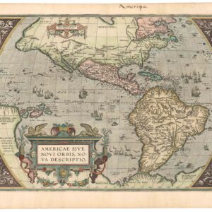
Americae Sive Novi Orbis, Nova Descriptio.
- $4,800
- The earliest acquirable map to name California.
-
-
-
-
Add to cart
 Quick View
 - North America
Nord America mit Westindien.
- $475
- A detailed German map of North America providing the latest configuration of the American West.
-
-
-
-
Add to cart
 Quick View
 - Americas, North America
Nord-Amerika.
- $1,200
- Von Sydow’s geophysical wall map of North America.
-
-
-
-
Add to cart
 Quick View
 - Americas, North America, Pacific Northwest - Hawaii - Alaska, Texas and The West
Map of Oregon Territory.
- $550
- One of the earliest maps of Oregon Territory.
-
-