-
-
Add to cart
 Quick View
 - California, San Francisco
Bird’s-eye-view of ruins of San Francisco from captive airship, 600 feet above Folsom between Fifth and Sixth Sts.
- $2,400
- Large, dramatic panoramic photograph surveying the devastation of the 1906 San Francisco earthquake and fire.
-
-
-
-
Add to cart
 Quick View
 - San Francisco
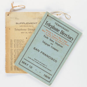
Temporary Telephone Directory with Supplement, San Francisco May 12, 1906
- $2,200
- The first 1906 San Francisco Temporary Telephone Directory - with rare extra supplement!
-
-
-
-
Add to cart
![[SAN FRANCISCO EARTHQUAKE PHOTO ALBUM]](https://neatlinemaps.com/wp-content/uploads/2023/02/126_127_1_lg-copy-300x300.jpg) Quick View
Quick View - San Francisco
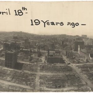
[SAN FRANCISCO EARTHQUAKE PHOTO ALBUM]
- $4,500
- A dramatic collection of photographs taken during and just after the devastating events of April 18, 1906.
-
-
-
-
Add to cart
 Quick View
 - San Francisco
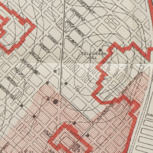
The San Francisco Earthquake and Fire of April 18, 1906 and their effects on structures and structural materials
- $875
- U.S. Government report on the 1906 earthquake, including two folding maps and a panoramic view of a city destroyed.
-
-
-
-
Add to cart
![5-sheet set showing San Francisco’s post-1906 earthquake water supply [SF’s first fireboat!]](https://neatlinemaps.com/wp-content/uploads/2022/03/NL-01375-sheet-4_thumbnail-scaled-300x300.jpg)
![5-sheet set showing San Francisco's post-1906 earthquake water supply [SF's first fireboat!]](https://neatlinemaps.com/wp-content/uploads/2022/03/NL-01375-sheet-4_thumbnail-scaled.jpg) Quick View
Quick View - San Francisco
5-sheet set showing San Francisco’s post-1906 earthquake water supply [SF’s first fireboat!]
- $5,500
- Four technical maps focussing on urban infrastructure and water supply and one engineering blueprint for a new fireboat, together reflecting San Francisco's coordinated response to the devastation of the 1906 earthquake. With an interesting provenance.
-
-
-
-
-
Add to cart
![[1906 EARTHQUAKE PANORAMA – FINANCIAL DISTRICT]](https://neatlinemaps.com/wp-content/uploads/2020/10/Screen-Shot-2023-02-06-at-6.55.56-PM-300x300.png) Quick View
Quick View - San Francisco
[1906 EARTHQUAKE PANORAMA – FINANCIAL DISTRICT]
- $3,400
- An urban panorama unlike any other: documentation of the devastation caused by the 1906 earthquake and fire.
-
-