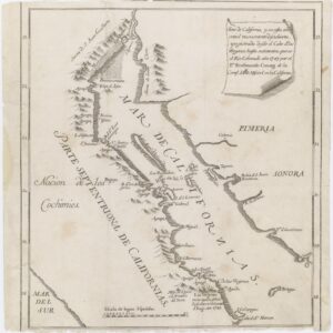
Fernando Consag (December 2, 1703 – September 10, 1759) was a Croatian Jesuit missionary, explorer, and cartographer.
In 1729, Consag left for Cádiz in Spain, then went to North America, where he was active as a missionary on New Spain’s Baja California Peninsula from 1732 to the end of his life.
Consag mounted three expeditions (in 1746, 1751, and 1753) systematically exploring previously unknown parts of the peninsula. On the basis of the data obtained, he made a precise map of Baja California (1748) and a map of the Gulf of California (around 1750).
His maps of the regions explored were popular at the time frequently copied and used. Denis Diderot and D’Alembert used some of them within the French encyclopedia, where his name is cited as “P. Consaqua.” Alexander von Humboldt used the maps in his work Carte generale … de la Nouvelle Espagne (Paris, 1804). The same is the case with Arrowsmith in his book Map of America, published in London in 1805.
Archived
- Out of Stock
- California, Mexico - Central & South America
Seno de California, y su costa oriental nuevamente descubierta, y registrada desde el Cabo de las Virgenas, hasta su termino, que es el Rio Colorado ano 1747…
- Consag’s seminal map of California, which conclusively ended the classic cartographic myth that California was an island.
- Read more
-
