-
-
Add to cart
 Quick View
 - World, Featured Maps & Views, Polar - Arctic
Hemispheriu Ab Aequinoctli Linea, Ad Circulu Poli Arctici/ Hemispheriu Ad Circulu Poli Atarctici.
- $57,500
- A superb example of De Jode’s seminal polar projection of the world.
-
-
-
-
Add to cart
![[Arctic Exploration] Nord Polar Karte von V. v. Haardt.](https://neatlinemaps.com/wp-content/uploads/2024/05/NL-02108_thumbnail-300x300.jpg) Quick View
Quick View - Polar - Arctic
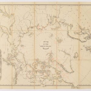
[Arctic Exploration] Nord Polar Karte von V. v. Haardt.
- $12,500
- The last great map of the North Pole before it was reached.
-
-
-
-
Add to cart
 Quick View
 - Polar - Arctic
Les deux poles arctique ou septentrional, et Antarctique ou meridional, ou description des terres arctiques et antarctiques, et des pays circomvoisins jusques aux 45 degres de latitude…1657
- $1,250
- An innovation in French cartography: Sanson's double polar projection from 1657.
-
-
-
-
Add to cart
 Quick View
 - Atlases & Books, Polar - Arctic
Narrative of the Second Arctic Expedition made by Charles F. Hall: His Voyage to Repulse Bay, Sledge Journeys to the Straights of Fury and Hecla and to King William’s Land, and Residence Among the Eskimos During the Years 1864-’69.
- $850
- Charles F. Hall's Second Expedition to the Arctic with an extraordinary family provenance.
-
-
-
-
Add to cart
 Quick View
 - Featured Maps & Views, Michael's Collection, Polar - Arctic
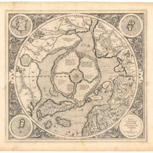
Septentrionalium Terrarum descriptio.
- $30,000
- History’s first dedicated map of the North Pole.
-
-