-
-
Add to cart
![[Dublin Bay]](https://neatlinemaps.com/wp-content/uploads/2026/05/NL-02629_thumbnail-300x300.jpg) Quick View
Quick View - British Isles, Europe
[Dublin Bay]
- $1,000
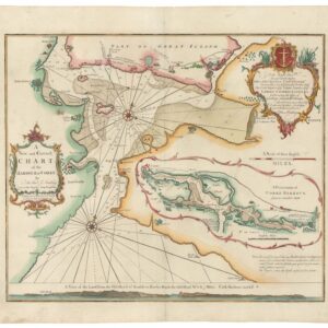
- 1693 Collins Nautical Chart of Dublin Bay, with Detailed Plan of the City.
-
-
-
-
Add to cart
![Schul-Wandkarte von dem Österreich-Ungarn [Politische Ausgabe].](https://neatlinemaps.com/wp-content/uploads/2026/05/NL-02638_thumbnail-300x300.jpg) Quick View
Quick View - Europe, Germany & the Netherlands, Greece & the Balkans
Schul-Wandkarte von dem Österreich-Ungarn [Politische Ausgabe].
- $850
- The Empire That Would Vanish in a Generation, Mapped at Its Height.
-
-
-
-
Add to cart
![[Carrickfergus Lough (Belfast)]](https://neatlinemaps.com/wp-content/uploads/2026/05/NL-02628_thumbnail-300x300.jpg) Quick View
Quick View - British Isles, Europe
[Carrickfergus Lough (Belfast)]
- $1,000
- 1693 Collins Nautical Chart of Belfast Lough, with Prospect of the Royal Landing at Carrickfergus.
-
-
-
-
Add to cart
![[The Irish Sea with the Isle of Man, Anglesey, and Lancashire]](https://neatlinemaps.com/wp-content/uploads/2026/05/NL-02627_thumbnail-300x300.jpg) Quick View
Quick View - British Isles, Europe
[The Irish Sea with the Isle of Man, Anglesey, and Lancashire]
- $500
- 1693 Collins Nautical Chart of the Northern Irish Sea, with the Isle of Man.
-
-
-
-
Add to cart
![[Falmouth]](https://neatlinemaps.com/wp-content/uploads/2026/05/NL-02625_thumbnail-300x300.jpg) Quick View
Quick View - British Isles, Europe
[Falmouth]
- $350
- 1693 Collins Nautical Chart of Falmouth Haven and the River Fal.
-
-
-
-
Add to cart
![[Part of Devon Shire]](https://neatlinemaps.com/wp-content/uploads/2026/05/NL-02622_thumbnail-300x300.jpg) Quick View
Quick View - British Isles, Europe
[Part of Devon Shire]
- $550
- 1693 Nautical Chart of South Devon and Torbay, with Vignette of William of Orange's Landing.
-
-
-
-
Add to cart
![[The Severn or Channell of Bristoll]](https://neatlinemaps.com/wp-content/uploads/2026/05/NL-02621_thumbnail-300x300.jpg) Quick View
Quick View - British Isles, Europe
[The Severn or Channell of Bristoll]
- $850
- 1693 Collins Nautical Chart of Bristol Channel, with Vignette of King William III's Landing.
-
-
-
-
Add to cart
 Quick View
 - British Isles, Europe
A New and Correct Chart of the Harbour of Corke by the Revd. J. Lindsay.
- $650
- 1759 Nautical Chart of Cork Harbour, Dedicated To George Anson.
-
-
-
-
Add to cart
 Quick View
 - Curiosities - Miscellanea, World
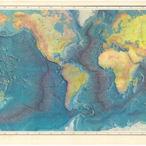
World Ocean Floor.
- $1,800
- 1977 Heezen & Tharp World Ocean Floor Map.
-
-
-
-
Add to cart
 Quick View
 - Arabia and the Red Sea, Middle East - Holy Land Maps
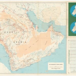
Saudi Arabian Road Map / خارطة طريق المملكة العربية السعودية
- $900
- 1973 Aramco Bilingual Road Map of the Arabian Peninsula.
-
-
-
-
Add to cart
 Quick View
 - Eastern Mediterranean - Holy Land, Middle East - Holy Land Maps
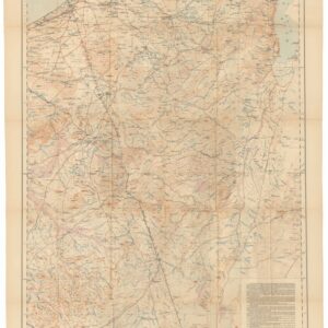
The Negeb or Desert south of Beersheba.
- $425
- 1921 War Office Map of the Negev, Based on the 1913–1914 Woolley-Lawrence-Newcombe Survey.
-
-
-
-
Add to cart
 Quick View
 - East & Midwest United States, United States
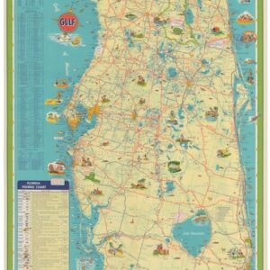
Florida — Gulf Vacation Map / Florida Georgia Vacation Map (cover).
- $150
- 1955 Gulf Oil Pictorial Road Map of Florida and the Southeastern United States.
-
-
Shop
All maps in stock, sorted by latest.