-
-
Add to cart
![San Francisco [June] 1849.](https://neatlinemaps.com/wp-content/uploads/2024/05/NL-01939_thumbnail-300x300.jpg) Quick View
Quick View - San Francisco
San Francisco [June] 1849.
- $4,800
- Henry Firks’ iconic birds-eye-view of San Francisco at the height of the Gold Rush.
-
-
-
-
Add to cart
 Quick View
 - Bay Area & Silicon Valley, Bird's-eye-views, California
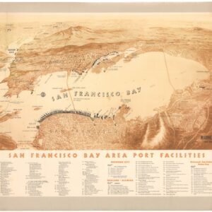
San Francisco Bay Area Port Facilities.
- $900
- A rare and splendid mid-century bird’s-eye-view highlighting maritime infrastructure in the Bay Area.
-
-
-
-
Add to cart
![[Forty-four photographs of shipbuilding in Oakland, California, 1918-1919.]](https://neatlinemaps.com/wp-content/uploads/2024/05/NL-01826-3_thumbnail-300x300.jpg) Quick View
Quick View - Bay Area & Silicon Valley, California
[Forty-four photographs of shipbuilding in Oakland, California, 1918-1919.]
- $925
- A unique collection of photographs documenting World War I shipbuilding activities at Oakland Harbor.
-
-
-
-
Add to cart
![Diario del Gobierno de la Republica Mexicana. Tome VII, Num. 697 [&] El Exmo. Sr. vice-presidente interino de los Estados-Unidos Mexicanos… Valentin Gómez Farías… sabed: …Sr. Presidente intorno D. Antonio Lopez de Santa-Anna, para mandar en persona y como general en gefe las fuerzas del ejécito…](https://neatlinemaps.com/wp-content/uploads/2024/05/NL-01744-1_thumbnail-300x300.jpg) Quick View
Quick View - Curiosities - Miscellanea
Diario del Gobierno de la Republica Mexicana. Tome VII, Num. 697 [&] El Exmo. Sr. vice-presidente interino de los Estados-Unidos Mexicanos… Valentin Gómez Farías… sabed: …Sr. Presidente intorno D. Antonio Lopez de Santa-Anna, para mandar en persona y como general en gefe las fuerzas del ejécito…
- $2,200
- Two rare official documents showcasing General Santa Anna’s pivotal role in the Texas Revolution and Mexican-American War.
-
-
-
-
Add to cart
 Quick View
 - United States, East & Midwest United States
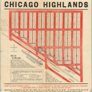
The Central Subdivision at Chicago Highlands.
- $775
- Promotional broadside for the industrial community of Chicago Highlands.
-
-
-
-
Add to cart
 Quick View
 - California
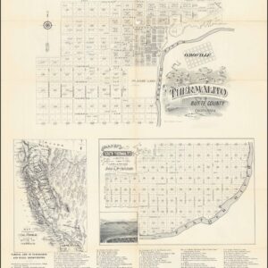
Map of Thermalito Butte County California | Map of South Thermalito Butte Co. Cal. Surveyed in April & May 188. By Bush & McCaustland. | Map of the State of Californai Showing Butte Co. and Thermalito.
- $1,100
- "The Pasadena of Central California."
-
-
-
-
Add to cart
![[AMERICAN REVOLUTION] Boston, George Washington, Franklin, Philadelphia, Washington, D.C.](https://neatlinemaps.com/wp-content/uploads/2024/05/NL-02090a_thumbnail-300x300.jpg) Quick View
Quick View - United States, East & Midwest United States
[AMERICAN REVOLUTION] Boston, George Washington, Franklin, Philadelphia, Washington, D.C.
- $600
- A set of six hand-colored plates from Guilio Ferrario’s iconic encyclopedia showcasing the American Revolution.
-
-
-
-
Add to cart
 Quick View
 - California, Curiosities - Miscellanea
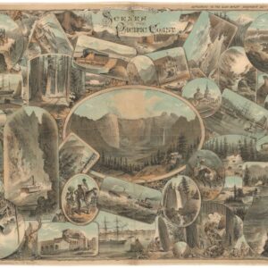
Scenes on the Pacific Coast.
- $2,800
- Pacific Panorama: Keller's Visual Tapestry of the West Coast.
-
-
-
-
Add to cart
 Quick View
 - California, Southern California
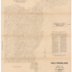
Hollywoodland, Tracts No. 6450 9367 9594.
- $1,800
- The birth of one of L.A.'s most iconic neighborhoods.
-
-
-
-
Add to cart
![Route of the Mormon Pioneers from Nauvoo to Great Salt Lake [Issued by the New Wilson European Hotel, Salt Lake City]](https://neatlinemaps.com/wp-content/uploads/2024/05/NL-02012_thumbnail-300x300.jpg) Quick View
Quick View - Texas and The West
Route of the Mormon Pioneers from Nauvoo to Great Salt Lake [Issued by the New Wilson European Hotel, Salt Lake City]
- A wonderful 1899 panoramic bird’s-eye-view of the route of the Mormon pioneers.
-
-
-
-
Add to cart
 Quick View
 - Middle East - Holy Land Maps, World War I and World War II
Lower Mesopotamia between Baghdad and the Persian Gulf.
- One of the most important early 20th-century maps of the Middle East.
-
-
-
-
Add to cart
 Quick View
 - East & Midwest United States
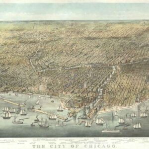
The City of Chicago.
- $6,500
- Probably the most iconic view of Chicago ever made…
-
-