-
-
Add to cart
 Quick View
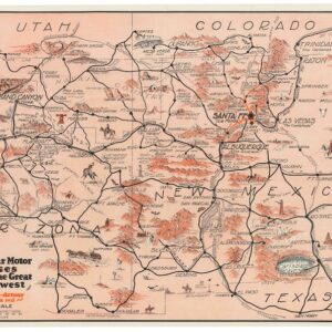
 - Pictorial maps, Texas and The West
Harveycar Motor Cruises Through the Great Southwest.
- $1,400
- A vibrant testimony to the birth of the American Road Trip.
-
-
-
-
Add to cart
 Quick View
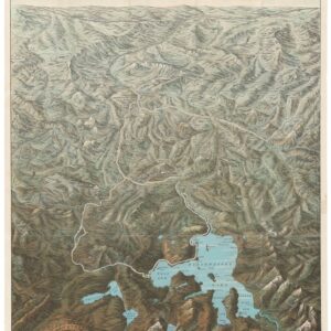
 - Bird's-eye-views, Pacific Northwest - Hawaii - Alaska, Texas and The West
Yellowstone National Park. Northern Pacific Railway / Northern Pacific Railway Company for Yellowstone National Park Puget Sound and Alaska.
- $1,250
- A magnificent view of one of America's most majestic parks in its original envelope.
-
-
-
-
Add to cart
 Quick View
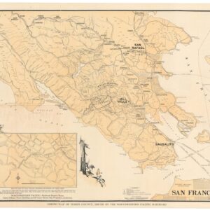
 - Bay Area & Silicon Valley, California, Railroad Maps
Hiking map of Marin County.
- $675
- 1930 Northwestern Pacific Railroad promotional hiking map of Marin County.
-
-
-
-
Add to cart
 Quick View
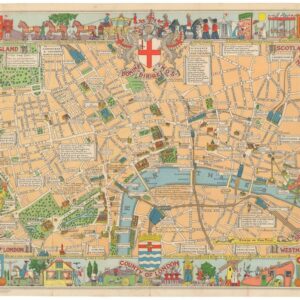
 - Europe, British Isles, Pictorial maps
County of London (Children’s Map of London).
- $575
- A rare early edition of the Children's Map of London.
-
-
-
-
Add to cart
 Quick View
 - Pictorial maps, United States
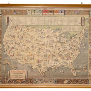
Folklore Music Map of the United States.
- $975
- A fantastic folklore map of America.
-
-
-
-
Add to cart
 Quick View
 - Eastern Mediterranean - Holy Land, Pictorial maps
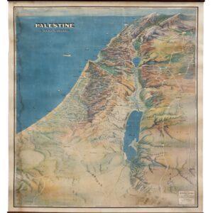
Palestine in Third Dimension.
- $1,600
- A Spectacular World War II-era View of the Holy Land.
-
-
-
-
Add to cart
![[Persuasive Cartography] Ubootswirkung im Mittelmeer.](https://neatlinemaps.com/wp-content/uploads/2024/05/NL-01997_thumbnail-300x300.jpg) Quick View
Quick View - Europe, World War I and World War II
[Persuasive Cartography] Ubootswirkung im Mittelmeer.
- $1,900
- World War I propaganda map of German submarine attacks.
-
-
-
-
Add to cart
 Quick View
 - Bay Area & Silicon Valley, Bird's-eye-views, California
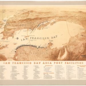
San Francisco Bay Area Port Facilities.
- $900
- A rare and splendid mid-century bird’s-eye-view highlighting maritime infrastructure in the Bay Area.
-
-
-
-
Add to cart
 Quick View
 - Middle East - Holy Land Maps, World War I and World War II
Lower Mesopotamia between Baghdad and the Persian Gulf.
- $1,400
- One of the most important early 20th-century maps of the Middle East.
-
-
-
-
Add to cart
 Quick View
 - Eastern Mediterranean - Holy Land, Bird's-eye-views
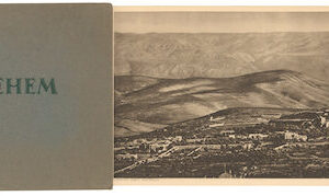
Bethlehem.
- $575
- Early 20th-century panoramic photo showing Bethlehem and its surroundings.
-
-
-
-
Add to cart
 Quick View
 - Pacific Northwest - Hawaii - Alaska, United States, Pictorial maps
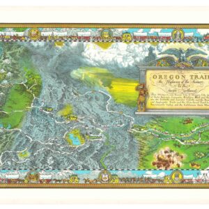
The Oregon Trail: The Highway of the Pioneers to the Pacific Northwest.
- $575
- William Forsyth McIlwraith’s vibrant and historically rich Oregon Trail map.
-
-
-
-
Add to cart
 Quick View
 - California, Pictorial maps
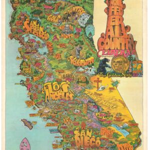
Home Federal Country. Eureka! The Golden State. California.
- $525
- Probably the best pictorial map of California from the early 1970s.
-
-