-
-
Add to cart
![[Panoramic Photograph] Fresno. 1000 ft Elevation.](https://neatlinemaps.com/wp-content/uploads/2025/10/NL-02428_thumbnail-300x257.jpg) Quick View
Quick View - California
[Panoramic Photograph] Fresno. 1000 ft Elevation.
- $1,800
- 1910 R.J. Waters panoramic aerial photo of Fresno, CA.
-
-
-
-
Add to cart
 Quick View
 - Atlases & Books, Canada and The Great Lakes, North America, United States
Joint maps of the northern boundary of the United States: from the Lake of the Woods to the summit of the Rocky Mountains.
- $500
- Defining the U.S.–Canadian border along the 49th parallel from the Lake of the Woods to the Rockies.
-
-
-
-
Add to cart
 Quick View
 - Asia
Operations in Waziristan 1919 – 1920. Confidential. Serial No. 224.
- $1,400
- Frontier warfare and colonial cartography: 1921 Survey of India “Confidential” atlas documenting the British campaign in Waziristan.
-
-
-
-
Add to cart
 Quick View
 - Bay Area & Silicon Valley, California
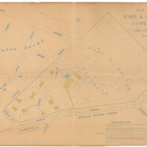
Map of Mary R. Smith’s Cottages.
- $1,400
- Rare 1907 map of Mary Smith’s East Oakland orphanage, a landmark of early Bay Area philanthropy.
-
-
-
-
Add to cart
 Quick View
 - Atlases & Books, California, World War I and World War II
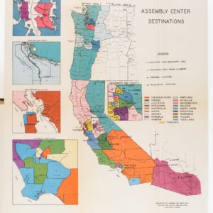
Japanese evacuation from the West Coast, 1942: Final Report.
- $775
- A chronicle of one of the most infamous events in American history.
-
-
-
-
Add to cart
![[Persuasive Cartography] La Cuestión Chilena.](https://neatlinemaps.com/wp-content/uploads/2025/10/NL-02415_thumbnail-300x300.jpg) Quick View
Quick View - Americas, Mexico - Central & South America
[Persuasive Cartography] La Cuestión Chilena.
- $975
- Argentinian propaganda map of Chile’s advance into Patagonia.
-
-
-
-
Add to cart
 Quick View
 - Eastern Mediterranean - Holy Land, Pictorial maps
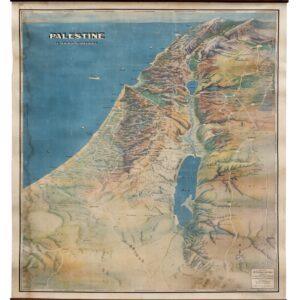
Palestine in Third Dimension.
- $975
- A Spectacular World War II-era View of the Holy Land.
-
-
-
-
Add to cart
![Road Map to the World Wide Web [verso: PC Computing The World Wide Web Business and Beyond].](https://neatlinemaps.com/wp-content/uploads/2025/09/NL-02439_thumbnail-300x300.jpg) Quick View
Quick View - Curiosities - Miscellanea
Road Map to the World Wide Web [verso: PC Computing The World Wide Web Business and Beyond].
- $1,600
- Route-mapping the internet for new users.
-
-
-
-
Add to cart
 Quick View
 - East & Midwest United States, United States
Gettysburg. Repulse of Longstreet’s Assault.
- $1,200
- Bachelder’s magnificent rendering of Longstreet’s Assault (Pickett's Charge).
-
-
-
-
Add to cart
 Quick View
 - Curiosities - Miscellanea, World
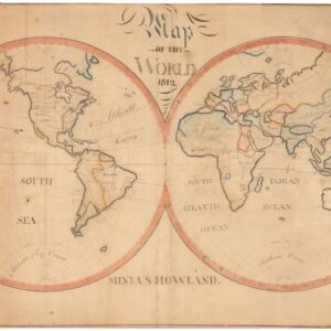
Map of the World. 1812.
- $1,800
- Drawing the world in 1812: a Quaker manuscript map blending myth and geography.
-
-
-
-
Add to cart
 Quick View
 - Arabia and the Red Sea, Middle East - Holy Land Maps
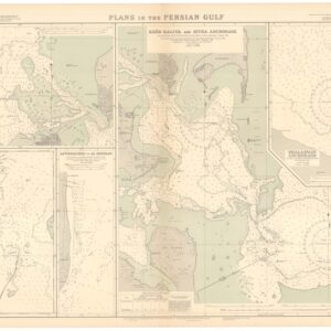
British Admiralty Chart No. 3789. Plans in the Persian Gulf.
- $2,400
- A British Admiralty map of the Persian Gulf, created at the dawn of Arabia’s emergent oil industry.
-
-
-
-
Add to cart
 Quick View
 - Curiosities - Miscellanea, San Francisco
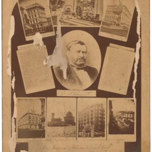
San Francisco’s Welcome to Gen. Grant. September 20, 1879.
- $1,200
- An unrecorded photographic commemoration of Ulysses S. Grant's 1879 visit to San Francisco.
-
-
Shop
All maps in stock, sorted by latest.