-
-
Add to cart
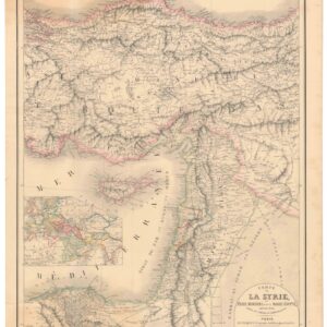
- Eastern Mediterranean - Holy Land
Carte de la Syrie, l’Asie Mineure et de la Basse Égypte, extraite de d’une carte de l’empire Ottoman en 12 flles.
- $400
- A French take on the Levant, twenty years before the expedition that initiated France’s colonial interest in the region.
-
-
-
-
Add to cart
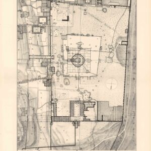
- Eastern Mediterranean - Holy Land
The Haram es-Sharif.
- $475
- A ground-breaking architectural plan of the Haram al-Sharif / Temple Mount.
-
-
-
-
Add to cart
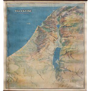
- Eastern Mediterranean - Holy Land, Pictorial maps, Wall maps
Palestine in Third Dimension.
- $1,600
- A Spectacular World War II-era View of the Holy Land.
-
-
-
-
Add to cart
![[Arabian Peninsula] Tabula Sexta de Asia.](https://neatlinemaps.com/wp-content/uploads/2024/05/NL-02008_thumbnail-300x300.jpg)
- Arabia and the Red Sea
[Arabian Peninsula] Tabula Sexta de Asia.
- $75,000
- A first state of Francesco Berlinghieri's map of Arabia, showing the Holy Cities of Mecca and Medina and the first faint depictions of Qatar and the United Arab Emirates.
-
-
-
-
Add to cart
- Turkey - Ottoman Empire
Plan der Stadt Constantinopel nebst deren nächsten Angrenzungen.
- $1,200
- A pair of plans of Istanbul made for Ottoman Sultan Abdul Aziz.
-
-
-
-
Add to cart

- Eastern Mediterranean - Holy Land
Ierusalem, et suburbia eius, sicut tempore Christi floruit…
- $3,300
- A magnificent High Renaissance plan of Jerusalem in the Second Temple Period.
-
-
-
-
Add to cart
![[Great Game] Map of Aderbeijan compiled principally from personal observations and surveys made in the years 1851-55 by N. Khanikof…](https://neatlinemaps.com/wp-content/uploads/2024/05/NL-01994_thumbnail-300x300.jpg)
- Iran - Persia - Central Asia
[Great Game] Map of Aderbeijan compiled principally from personal observations and surveys made in the years 1851-55 by N. Khanikof…
- $2,400
- Russian Orientalist Nikolai Khanykov’s map of Greater Azerbaijan.
-
-
-
-
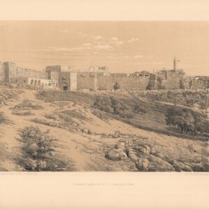
Add to cart
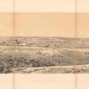
- Eastern Mediterranean - Holy Land
Panorama of Jerusalem, seen from the Mount of Olives.
- $575
- A fantastic mid-19th-century panoramic view of Jerusalem.
-
-
-
-
Add to cart

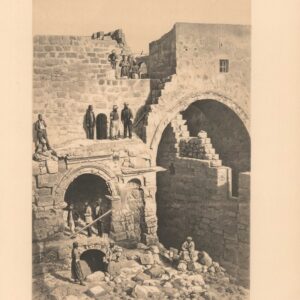
- Eastern Mediterranean - Holy Land
Gate of Damascus.
- $300
- Jerusalem's famous Damascus Gate.
-
-
-
-
Add to cart
![[Persia & Mesopotamia] Tabula Quinta de Asia.](https://neatlinemaps.com/wp-content/uploads/2024/05/NL-02006-NEW_thumbnail-300x300.jpg)
- Iran - Persia - Central Asia
[Persia & Mesopotamia] Tabula Quinta de Asia.
- $15,000
- One of the oldest maps of Persia and Mesopotamia, the Cradle of Civilizations.
-
-