-
-
Add to cart
 Quick View
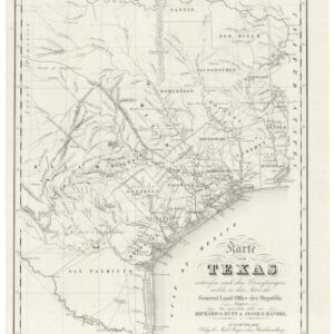
 - Texas and The West
Karte von Texas entworfen nach den Vermessungen, welche in den Acten der General-Land-Office der Republic liegen bis zum Jahr 1839 von Richard S. Hunt & Jesse F. Randel…1841.
- $6,000
- A rare German capture of the young Republic of Texas.
-
-
-
-
Add to cart
 Quick View
 - East & Midwest United States
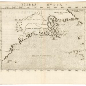
Tierra Nueva.
- $1,800
- A true first state of one the earliest maps of the Eastern Seaboard.
-
-
-
-
Add to cart
 Quick View
 - Pacific Northwest - Hawaii - Alaska
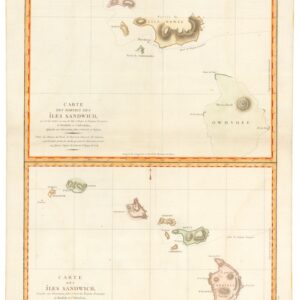
Carte des Parties des Îles Sandwich & Carte des Îles Sandwich.
- $1,600
- History’s second mapping of Hawaii.
-
-
-
-
Add to cart
 Quick View
 - United States, Pictorial maps
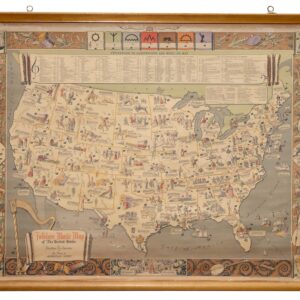
Folklore Music Map of the United States.
- $975
- A fantastic folklore map of America.
-
-
-
-
Add to cart
 Quick View
 - Americas, North America, Pacific Northwest - Hawaii - Alaska, Texas and The West
Map of Oregon Territory.
- $550
- One of the earliest maps of Oregon Territory.
-
-
-
-
Add to cart
 Quick View
 - North America, United States, Americas
Charte Von Nord America Entworfen und gezeichnet von C.G. Reichard…Erganztr und nach den neuern Entdeckungen desr Hrn. Lewis, Clarke n. Pike…1817.
- $1,600
- A noteworthy and era-specific snapshot of North American geography and exploration during the early 19th century.
-
-
-
-
Add to cart
 Quick View
 - United States, East & Midwest United States
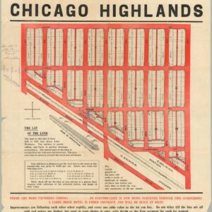
The Central Subdivision at Chicago Highlands.
- $775
- Promotional broadside for the industrial community of Chicago Highlands.
-
-
-
-
Add to cart
 Quick View
 - Atlases & Books, California, Texas and The West
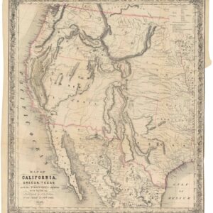
Map of California, Oregon, Texas, and the territories adjoining, with routes &c.
- $1,900
- Colton’s iconic map of the West, with California Gold region and extended Texas borders.
-
-
-
-
Add to cart
![[AMERICAN REVOLUTION] Boston, George Washington, Franklin, Philadelphia, Washington, D.C.](https://neatlinemaps.com/wp-content/uploads/2024/05/NL-02090a_thumbnail-300x300.jpg) Quick View
Quick View - United States, East & Midwest United States
[AMERICAN REVOLUTION] Boston, George Washington, Franklin, Philadelphia, Washington, D.C.
- $600
- A set of six hand-colored plates from Guilio Ferrario’s iconic encyclopedia showcasing the American Revolution.
-
-
-
-
Add to cart
![Route of the Mormon Pioneers from Nauvoo to Great Salt Lake [Issued by the New Wilson European Hotel, Salt Lake City]](https://neatlinemaps.com/wp-content/uploads/2024/05/NL-02012_thumbnail-300x300.jpg) Quick View
Quick View - Texas and The West
Route of the Mormon Pioneers from Nauvoo to Great Salt Lake [Issued by the New Wilson European Hotel, Salt Lake City]
- $775
- A wonderful 1899 panoramic bird’s-eye-view of the route of the Mormon pioneers.
-
-
-
-
Add to cart
 Quick View
 - East & Midwest United States
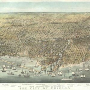
The City of Chicago.
- $6,500
- Probably the most iconic view of Chicago ever made…
-
-
-
-
Add to cart
 Quick View
 - Pacific Northwest - Hawaii - Alaska, Pictorial maps, United States
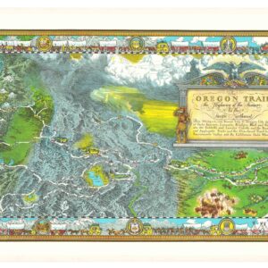
The Oregon Trail: The Highway of the Pioneers to the Pacific Northwest.
- $575
- William Forsyth McIlwraith’s vibrant and historically rich Oregon Trail map.
-
-