-
-
Add to cart
 Quick View
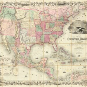
 - Featured Maps & Views, Texas and The West, United States
Map of the United States of America, The British Provinces, Mexico, The West Indies and Central America, with part of New Granada and Venezuela.
- $8,500
- A First State of Colton's Map of the United States with Texas extending into Colorado.
-
-
-
-
Add to cart
 Quick View
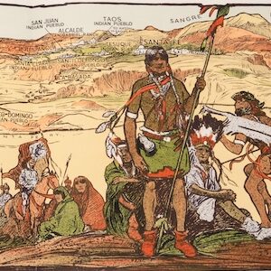
 - United States, Texas and The West, Pictorial maps
The Indian-detour; Santa Fe; Harveycars.
- $1,400
- The Roots of Romanticism of the American Southwest.
-
-
-
-
Add to cart
 Quick View
 - California, Texas and The West, United States
Map of the United States Mexico &c. Showing the various Land and Water Routes from the Atlantic Cities to California
- $750
- A scarce map from the early days of the Gold Rush.
-
-
-
-
Add to cart
 Quick View
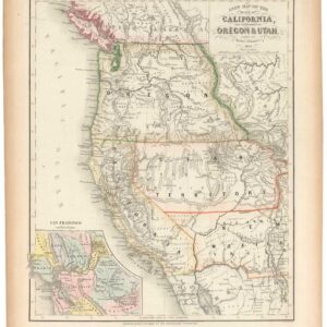
 - California, Texas and The West
A New Map of the State of California, the Territories of Oregon & Utah…
- $675
- Promoting California and the Gold Rush to a Receptive Audience.
-
-
-
-
Add to cart

 Quick View
 - United States, Texas and The West
Williams New Trans-Continental Map of The Pacific R.R. and Routes of Overland Travel To Colorado, Nebraska, The Black Hills, Utah, Idaho, Nevada, Montana California and the Pacific Coast.
- $3,500
- 1876 Pacific Railroad map with references to notorious stagecoach robber Black Bart.
-
-

-

-
-
-
Add to cart
 Quick View
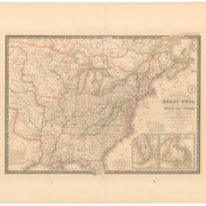
 - East & Midwest United States, Texas and The West
Carte Générale des Etats-Unis, des Haut et Bas-Canada, de la Nouvelle Ecosse, du Nouvelle Brunswick, de Terre Neuve.
- $875
- Brué’s important map of the United States prior to the Mexican-American War, with an overtly independent Texas.
-
-
-
-
Add to cart
 Quick View
 - Pictorial maps, Texas and The West
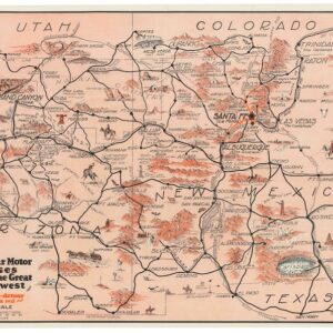
Harveycar Motor Cruises Through the Great Southwest.
- $1,400
- A vibrant testimony to the birth of the American Road Trip.
-
-
-
-
Add to cart
 Quick View
 - Bird's-eye-views, Pacific Northwest - Hawaii - Alaska, Texas and The West
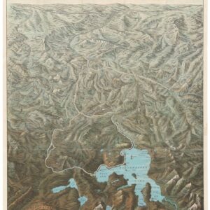
Yellowstone National Park. Northern Pacific Railway / Northern Pacific Railway Company for Yellowstone National Park Puget Sound and Alaska.
- $1,250
- A magnificent view of one of America's most majestic parks in its original envelope.
-
-
-
-
Add to cart
 Quick View
 - California, Texas and The West, Mexico - Central & South America
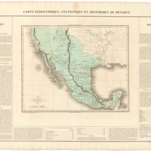
Carte Geographique, Statistique, et Historique du Mexique (incl. Alta California).
- $475
- The First Mexican Empire, including Alta California.
-
-
-
-
Add to cart
 Quick View
 - Texas and The West
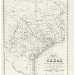
Karte von Texas.
- $6,000
- Highly sought after by collectors of Texas and German-American history.
-
-
-
-
Add to cart
 Quick View
 - Americas, North America, Pacific Northwest - Hawaii - Alaska, Texas and The West
Map of Oregon Territory.
- $550
- One of the earliest maps of Oregon Territory.
-
-
-
-
Add to cart
 Quick View
 - California, Texas and The West, Atlases & Books
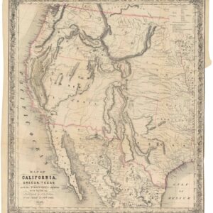
Map of California, Oregon, Texas, and the territories adjoining, with routes &c.
- $1,900
- Colton’s iconic map of the West, with California Gold region and extended Texas borders.
-
-