Józef Michal Bazewicz (1867-1929) was a cartographer, writer, and bookseller, based in Warsaw during the early 20th century. He was a leading figure among the city’s intelligentsia and cultural elite, and an open supporter of Poland’s right to independence from the great powers in Europe.
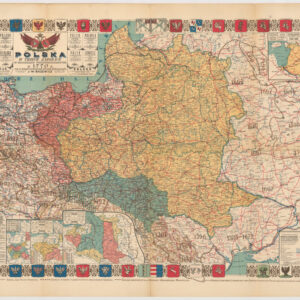
Bazewicz issued several cartographic publications for which he gained some renown. In 1916, before Polish independence, he published a national historical atlas of Poland, in Polish (Atlas historyczny Polski). In 1921, he published a book which dealt with Polish political history from the Middle Ages until the First Partition. This included a large folding map of Europe – and Poland prominent place in it – during the 14th and 15th centuries. But the epitome of his cartographic career came the following year, when Basewicz published a large national chart that both depicted the new Polish nation in all its glory, but also incorporated the country’s long history, as a means of historical legitimizing it. This map, Polska W Trzech Zaborach W Granicach Przedrozbiorowych W 1770 R. Oraz W Innych Wazniejszych Okresach Historycznych, is still considered one of the most important modern maps of Poland ever produced.
Archived
- Out of Stock
- Russia & Eastern Europe
Polska W Trzech Zaborach W Granicach Przedrozbiorowych W 1770 R. Oraz W Innych Wazniejszych Okresach Historycznych
- This vivacious map of an independent and unified Poland was created after the end of The Great War. For the first time in more than a century, Poland was again a whole and autonomous nation. This map is a celebration of that freedom, and of the historical process that lead to it.
- Read more
-