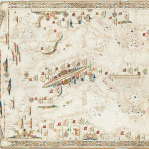
Joan Oliva came from an extended family of mapmakers that for multiple generations dominated the portolan market during the 16th and 17th centuries. The family originally came from Spain, probably arriving in Italy with the fleet of Charles V in 1527. At some point, a branch of the family settled in Sicily, where they established their name as leading cartographers in the Messina school. Known charts from the Oliva family span in date from 1538 to 1673, some of them bearing the signatures of no less than sixteen family members on a single chart. Indeed our chart seems to have been completed by Joan Oliva’s relation, Placitus Caloirus, who put his name prominently at the northwestern corner of the chart. The fact that this chart so clearly forms the basis for Oliva’s 1618 portolan, which we know he compiled and drew himself, has repeatedly validated this chart as the work of Joan Oliva, and not the unknown Caloirus.
Joan Oliva worked from multiple locations during his lifetime, starting in Messina and probably ending his career in Marseilles. But members of the greater Oliva family have been registered as working in diverse places as Naples, Livorno, Florence, Venice, Palermo, Messina, Mallorca, and Malta. The extent of the clan and the exact nature of their genealogy remains obscure, but Joan Oliva figures prominently as the most prolific and highly regarded mapmaker of the family. Over the course of the 16th and early 17th century, he produced some of the most exquisite and rare portolan charts and atlases known to man.
We do not know exactly when or where Joan Oliva died, but his output decreases significantly during in the 1620s. We know of two charts from 1627 in a private Portuguese collection and a 1629 chart of Sardinia that was compiled by Joan Oliva himself while living in Livorno (Astenga 2007: 180). Besides this, there are at least two additional maps signed ‘Placitus Caloirus et Oliva’, dated to 1621 and 1636 respectively. It is quite likely that these were adaptions of Joan Oliva’s work, finalized and compiled by the same family member that was involved in our chart. Joan Oliva may nevertheless have been active well into the 1630s, since a chart attributed to him and dated 1634 used to be held in the Biblioteca Trivulziana in Milan. Sadly, this was destroyed along with most of the extensive map collection, when the library was bombed during World War II. It is of course possible that the 1634 and 1636 charts were compiled long after Joan Oliva’s death, but using his notes and drafts.
Archived
- Out of Stock
- Featured Maps & Views, World
Placitus Caloirus et Oliva fecit in nobili urbe messane año 1617
- This is the Yates-Houghton “Doppia” Portolan, a rare and beautiful masterpiece that delineates a revolution in geographic understanding and represents the dawn of scientifically-anchored cartography.
- Read more
-