-
-
Add to cart
- Featured Maps & Views, World
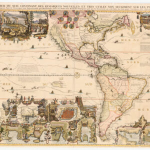
Carte Très Curieuse de la Mer du Sud, Contenant des Remarques Nouvelles et Tres Utiles non Seulement sur les Ports et Iles de Cette Mer
- $16,000
- Henri Chatelain’s magnificent map of the Western Hemisphere in extraordinary color and condition.
-
-
-
-
-
Add to cart
- Asia
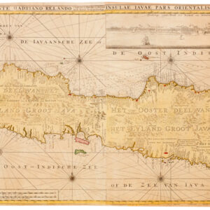
Insulae Iavae Pars Occidentalis Edente Hadriano Relando…Insulae Iavae Pars Orientalis Edente Hadriano Relando
- $4,900
- The beating heart of Dutch East India: a rare and beautiful second state of Gerard van Keulen’s visually overwhelming map of Java.
-
-
-
-
-
Add to cart
- Eastern United States
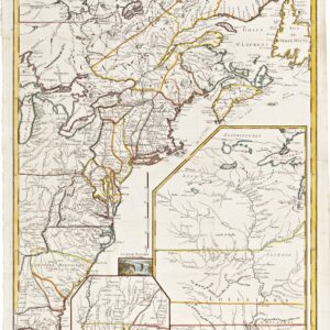
Carte D’Une Partie De L’Amerique Septentrionale, pour servir a l’Histoire derniere Guerre
- $1,400
- Mapping post-independence America: 1787 Le Rouge map of the East Coast and the Mississippi Valley.
-
-
-
-
-
Add to cart
- Africa
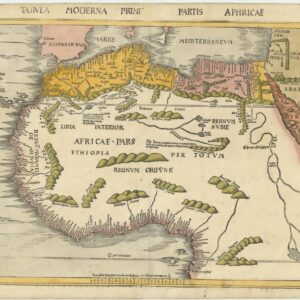
Tabula Moderna Prime Partis Aphricae
- $9,000
- Gorgeous example of famed cartographer Martin Waldessemüller’s double-page woodcut map of North and West Africa.
-
-
-
-
-
Add to cart
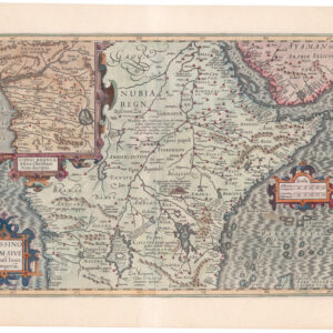
- Africa
Abissinorum Sive Pretiosi Ioannis Imperiu.
- $525
- Hondius map of East Africa with the Kingdom of Prester John and inset of the Congo.
-
-
-
-
-
Add to cart
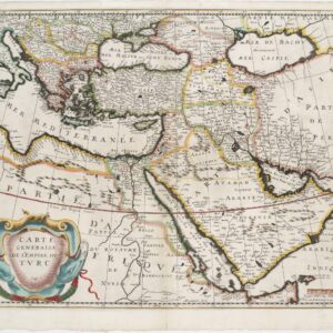
- Turkey - Ottoman Empire
Carte Généralle de l’Empire du Turc.
- $750
- Mid-17th century map of the Ottoman Empire with various Arabian cartographic myths.
-
-
-
-
-
Add to cart

- Africa, Arabia and the Red Sea
Occidentalior Tractus Indiarum Orientalium à Promontorio Bonae Spei ad C. Comorin
- $1,400
- Stunning Renard sea chart of the Indian Ocean, with East Africa, Arabia, and southern India, from the Atlas de la Navigation.
-
-
-
-
-
Add to cart
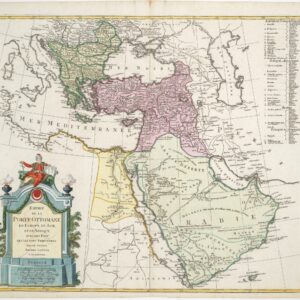
- Turkey - Ottoman Empire
Empire de la porte Ottomane en Europe, en Asie, et en Afrique avec les pays qui lui sont tributaires, dressé par les freres Lotter
- $675
- Late 18th century map of the Ottoman Empire with large, striking cartouche.
-
-
-
-
-
Add to cart
![Cuba Insula [with] Hispaniola Insula [with] Insula Jamaica [with] Ins. S. Ioannis [with] I.S. Margareta Cum Confiniis](https://neatlinemaps.com/wp-content/uploads/2019/09/NL-00611_thumbnail-300x300.jpg)
- Cuba, West Indies, Caribbean
Cuba Insula [with] Hispaniola Insula [with] Insula Jamaica [with] Ins. S. Ioannis [with] I.S. Margareta Cum Confiniis
- $500
- Rare English edition of the Mercator-Hondius map of Carribean islands, including an inset of Havana.
-
-
-
-
Add to cart
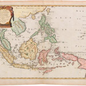
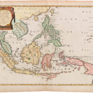
- Asia
Les Isles Philippines Molucques et de la Sonde
- $875
- Fine 1654 French map centered on the Philippines, and with Singapore.
-
-
-
-
-
Add to cart
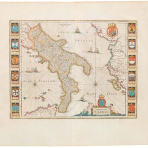
- Italy
Regno di Napoli.
- Handsome 1640 map of southern Italy with decorative coats-of-arms.
-
-
-
-
-
Add to cart
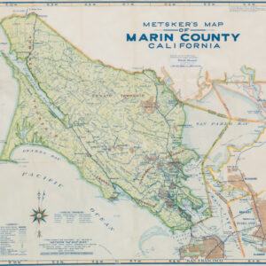
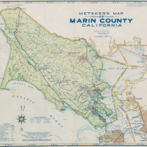
- Marin, Sonoma, & Napa Valley
Metsker’s map of Marin County California
- $475
- Before the Richmond-San Rafael Bridge: a detailed post-WWII map of Marin County in attractive colors.
-
-
-