-
-
Add to cart
- San Francisco, Railroad Maps
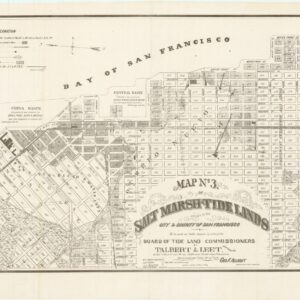
Map no. 3. Salt marsh and tide lands situate in the city and county of San Francisco. To be sold at public auction by order of the Board of Tide Land Commissioners by Talbert & Leet, auctioneers, at their sales rooms no. 526 California Street, San Francisco. Sale to commence Friday Nov. 26th, 1869.
- $3,400
- Rare cadastral and Southern Pacific Railroad right-of-way tidal lands map of Mission Bay.
-
-
-
-
-
Add to cart
- San Francisco
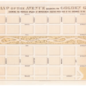
Map of the Avenue leading to Golden Gate Park Showing the Proposed Plan of Improvement, Together with that of the Entrance to the Park
- $250
- 1872 William Hammond Hall map of the Panhandle.
-
-
-
-
-
Add to cart
![[Pair of views] Rade et Ville de Sincapour & Rade de Sincapour prise de la maison du Gouverneur](https://neatlinemaps.com/wp-content/uploads/2021/03/NL-00896-harbor_Thumbnail-300x300.jpg)
- Asia, Bird's-eye-views
[Pair of views] Rade et Ville de Sincapour & Rade de Sincapour prise de la maison du Gouverneur
- $7,000
- Two of the earliest obtainable views of Singapore.
-
-
-
-
-
Add to cart
- United States
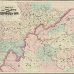
Colton’s Map of the Oil District of West Virginia and Ohio
- $3,600
- Mapping an early American oil boom: rare first state of Colton's Map of West Virginia and Ohio.
-
-
-
-
-
Add to cart
- Cuba, West Indies, Caribbean
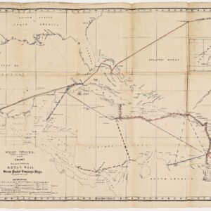
West Indies. New Chart shewing the Routes of the Royal Mail Steam Packet Company’s Ships.
- $2,500
- The communications lifeline of the British Caribbean: an unrecorded map of the Royal Mail Steam Packet Company’s Ships to the West Indies.
-
-
-
-
-
Add to cart
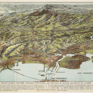
- Bird's-eye-views, San Francisco Bay Area & Silicon Valley
Mount Diablo, Historic Meridian Mountain, and Routes of Motorways to Summit
- $575
- Excellent Worthington Gates bird's-eye-view of the East Bay and Mt. Diablo.
-
-
-
-
-
Add to cart
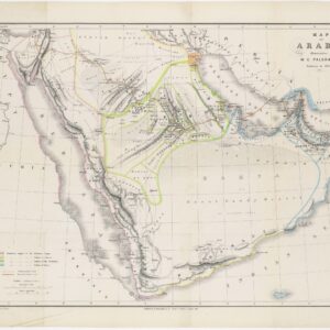
- Arabia and the Red Sea
Map of Arabia illustrative of W.G. Palgrave’s Journey in 1862-63
- $500
- 19th century map of the Arabian Peninsula with important contemporary political divisions.
-
-
-
-
-
Add to cart
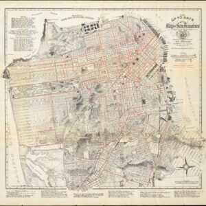
- San Francisco
The up to date map of San Francisco: from latest U. S. Gov. and official surveys.
- $975
- Scarce pocket map by the famous August Chevalier.
-
-
-
-
-
Add to cart
- San Francisco, San Francisco Bay Area & Silicon Valley
Map of the Spring Valley Water Works compiled from actual surveys
- $500
- Bringing water from Calaveras Reservoir to Crystal Springs - Spring Valley Water Works pipe line map.
-
-
-
-
-
Add to cart

- San Francisco, San Francisco Bay Area & Silicon Valley
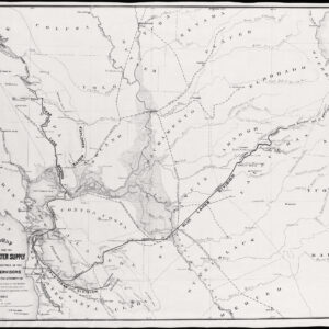
General Map of the Surveys for the San Francisco Water Supply made under the direction of the Board of Supervisors…
- $600
- Large, impressive San Francisco water supply system map.
-
-
-
-
-
Add to cart

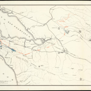
- Texas and The West
Map of a Reconnoissance between Fort Leavenworth on the Missouri River, and the Great Salt Lake in the Territory Of Utah…
- $650
- One of the seminal cartographic achievements for the mapping of the West, professionally backed on sturdy linen.
-
-
-
-
-
Add to cart
- Texas and The West
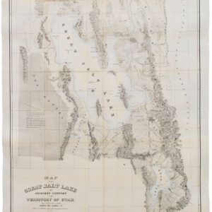
Map of the Great Salt Lake And Adjacent Country in the Territory Of Utah. Surveyed in 1849 and 1850…
- $850
- "Scientific cartography of the Territory of Utah may be said to date from the appearance of this map." - Wheat
-
-
-