-
-
Add to cart

- Bird's-eye-views, Pictorial maps, San Francisco
Bart Opens Embarcadero. First port o’call in San Francisco
- $275
- Celebrating public transit -- a pictorial view of downtown San Francisco announcing the 1976 opening of the Embarcadero BART station.
-
-
-
-
-
Add to cart
- United States, Pictorial maps
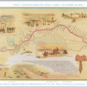
Pony Express Route April 3, 1860 – October 24, 1861
- $350
- A vivid 1961 pictorial commemoration of the Pony Express centennial.
-
-
-
-
-
Add to cart

- Turkey - Ottoman Empire, Rare Maps of Curiosities - Miscellanea
Plan of Ancient Troy
- $175
- When artifact becomes cartifact -- locally-published and detailed archaeological plan of Ancient Troy.
-
-
-

-
-
-
Add to cart
- California, Pictorial maps
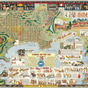
Carmel-By-the-Sea Past and Present (with original envelope!)
- $1,800
- This information-packed, cartoon-style map of Carmel-by-the-Sea in California is a typical example of Jo Mora’s innovative style of mapmaking and one of the most iconic maps from his hand.
-
-
-
-
-
Add to cart

- Marin, Sonoma, & Napa Valley, Pictorial maps
Marvelous Marin, Home of Muir Woods National Monument
- $275
- A marvelous work for a marvelous place: a 1960s pictorial map of Marin County, CA.
-
-
-
-
-
Add to cart
![The Original Silicon Valley Map & Calendar [1994]](https://neatlinemaps.com/wp-content/uploads/2021/06/NL-00909_Thumbnail-300x300.jpg)
- Bird's-eye-views, Pictorial maps, San Francisco Bay Area & Silicon Valley
The Original Silicon Valley Map & Calendar [1994]
- $775
- On the eve of the dot-com bubble: a vibrant 1994 pictorial bird's-eye-view of Silicon Valley.
-
-
-
-
-
Add to cart

- San Francisco, Bird's-eye-views, Rare City Plans
San Francisco
- Special 1974 pictorial map of San Francisco issued by the Mark Hopkins Hotel.
-
-
-
-
-
Add to cart
- San Francisco Bay Area & Silicon Valley
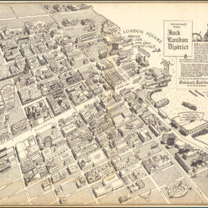
Internationally Famous Jack London District…Oakland, California.
- $825
- A scarce 1952 pictorial map promoting Oakland's Jack London District, published just one year after its dedication.
-
-
-
-
-
Add to cart

- Rare Maps of Curiosities - Miscellanea, United States
They’ve got an invisible program to end an undeclared war backed by a silent majority.
- $750
- A sharp anti-Vietnam War protest broadside that captured the zeitgeist of the time, matched the moment, and pulled no punches.
-
-
-
-
-
Add to cart
![Oakland [1993 calendar map]](https://neatlinemaps.com/wp-content/uploads/2021/02/NL-00892_Thumbnail-300x300.jpg)
- Pictorial maps, San Francisco Bay Area & Silicon Valley
Oakland [1993 calendar map]
- $345
- Early 1990s pictorial bird's-eye-view of Oakland, CA.
-
-
-
-
-
Add to cart
- Asia, Iran - Persia - Central Asia, Rare Maps of Curiosities - Miscellanea
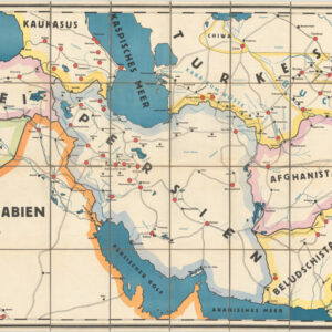
Wandkarte der Teppichgebiete
- $1,350
- A remarkable visualization of well-known carpet regions in the Middle East and Central Asia, produced at the height of the ‘Persian rug craze’.
-
-
-
-
-
Add to cart

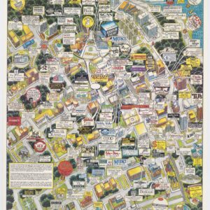
- United States, Bird's-eye-views
Hyde Park Illinois
- $675
- The University and its environs: a bird's-eye-view pictorial map of Hyde Park Chicago.
-
-
-