-
-
Add to cart
 Quick View
 - Eastern Mediterranean - Holy Land, Middle East - Holy Land Maps
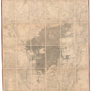
Ordnance Survey of Jerusalem By Captain Charles W. Wilson R.E. Under The Direction of Colonel Sir Henry James, R.E. F.R.S. & C. Director of the Ordnance Survey. 1864-5.
- $3,500
- 1865 British Survey of Jerusalem: the First Scientific Mapping of the City and its Environs.
-
-
-
-
Add to cart
 Quick View
 - Americas, Cuba, West Indies, Caribbean
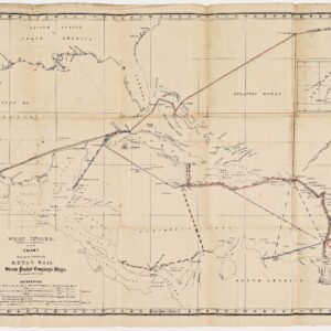
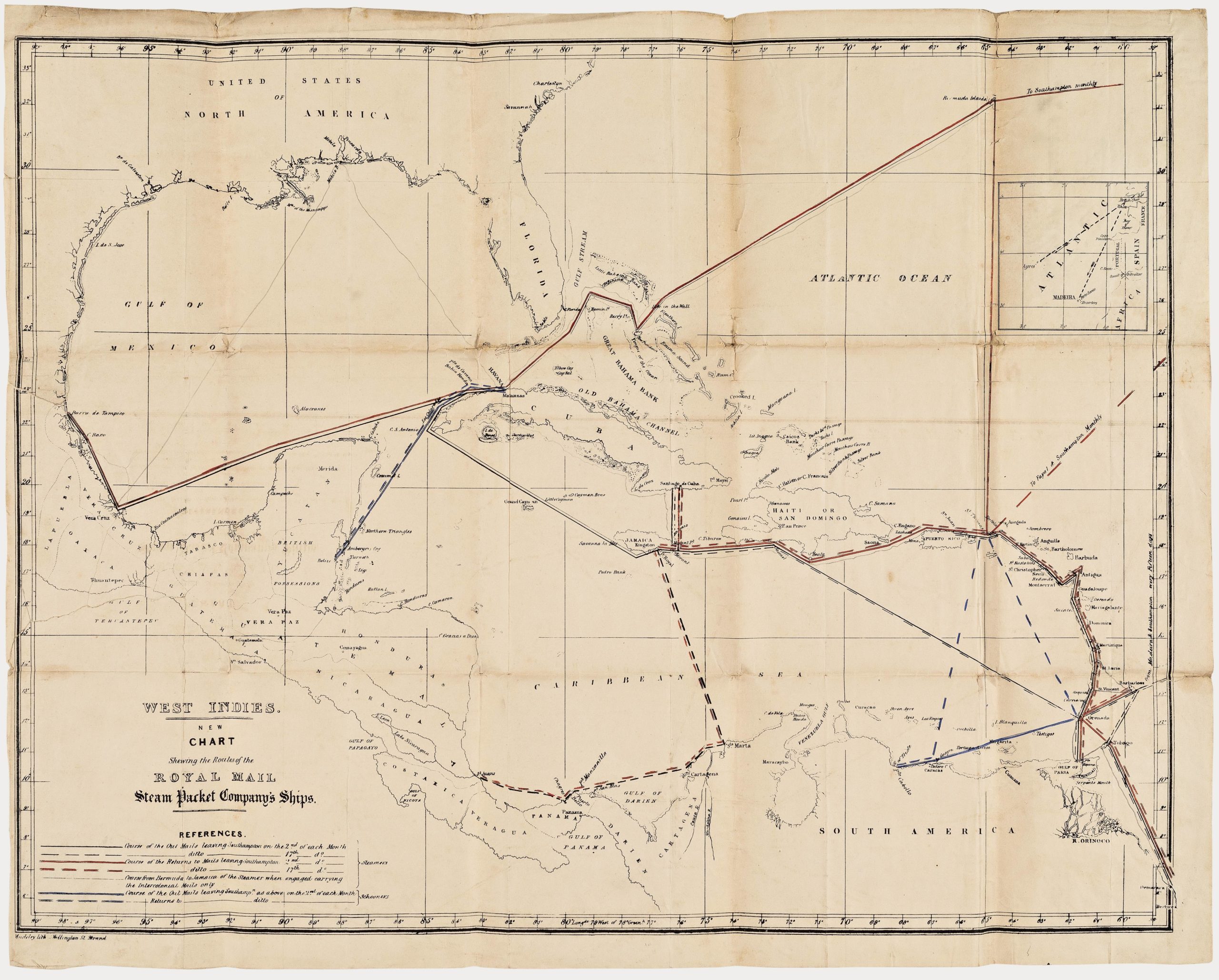
West Indies. New Chart shewing the Routes of the Royal Mail Steam Packet Company’s Ships.
- $2,400
- The communications lifeline of the British Caribbean: an unrecorded map of the Royal Mail Steam Packet Company’s Ships to the West Indies.
-
-
-
-
-
Add to cart
 Quick View
 - Curiosities - Miscellanea, Pictorial maps, World
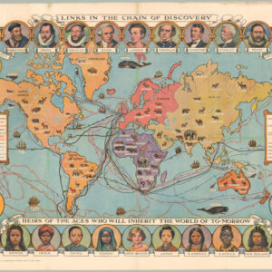
Cassell’s Children’s Book of Knowledge Wonder Map of the World.
- $450
- Thematic mapping for children: a fabulous circa 1930 world map depicting the history of exploration.
-
-
-
-
-
Add to cart
 Quick View
 - Africa
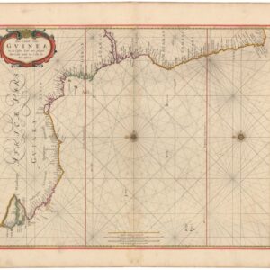
Pas-Caart van Guinea en de Custen daer aen gelegen Van Cabo verde tot Cabo de Bona Esperanca.
- $750
- 1670s Goos Sea Chart of the West African Coast from Cape Verde to the Cape of Good Hope.
-
-
-
-
Add to cart
 Quick View
 - Europe, Iceland & Scandinavia
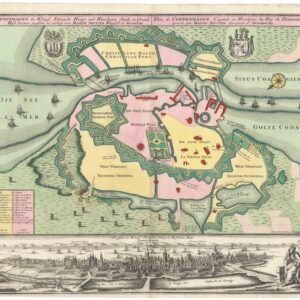
Coppenhagen die Königl. Dänische Haupt und Residentz Stadt in Grund Riss.
- $1,600
- 1740 Seutter Ground Plan of Copenhagen with Panoramic View.
-
-
-
-
Add to cart
![[The Isle of Wight and the Solent Approaches]](https://neatlinemaps.com/wp-content/uploads/2026/05/NL-02635_thumbnail-300x300.jpg) Quick View
Quick View - British Isles, Europe
[The Isle of Wight and the Solent Approaches]
- $800
- 1693 Collins Nautical Chart of the Isle of Wight, the Solent, and the Approaches to Portsmouth and Spithead.
-
-
-
-
Add to cart
![[Kingsale Harbour]](https://neatlinemaps.com/wp-content/uploads/2026/05/NL-02634_thumbnail-300x300.jpg) Quick View
Quick View - British Isles, Europe
[Kingsale Harbour]
- $400
- 1693 Collins Nautical Chart of Kinsale Harbour, with Plans of Charles Fort and Rincorran Castle.
-
-
-
-
Add to cart
![[The Chiefe Harbours in the Islands of Orkney]](https://neatlinemaps.com/wp-content/uploads/2026/05/NL-02632_thumbnail-300x300.jpg) Quick View
Quick View - British Isles, Europe
[The Chiefe Harbours in the Islands of Orkney]
- $500
- 1693 Collins Nautical Chart of the Principal Harbors of Orkney.
-
-
-
-
Add to cart
![[Untitled Sectional County Map of Colorado]](https://neatlinemaps.com/wp-content/uploads/2026/05/NL-02489_thumbnail-300x300.jpg) Quick View
Quick View - Texas and The West, United States
[Untitled Sectional County Map of Colorado]
- $500
- 1905 circa Large-Format Wall Map of Colorado at the Height of the Western Boom.
-
-
-
-
Add to cart
![[Edinburgh Firth]](https://neatlinemaps.com/wp-content/uploads/2026/05/NL-02631_thumbnail-300x300.jpg) Quick View
Quick View - British Isles, Europe
[Edinburgh Firth]
- $1,000
- 1693 Collins Nautical Chart of the Firth of Forth, with Plan of Edinburgh.
-
-
-
-
Add to cart
![[The East Coast of Scotland, Orkney and Shetland]](https://neatlinemaps.com/wp-content/uploads/2026/05/NL-02630_thumbnail-300x300.jpg) Quick View
Quick View - British Isles, Europe
[The East Coast of Scotland, Orkney and Shetland]
- $600
- 1693 Collins Nautical Chart of the East Coast of Scotland, Orkney, and Shetland.
-
-
-
-
Add to cart
![[Dublin Bay]](https://neatlinemaps.com/wp-content/uploads/2026/05/NL-02629_thumbnail-300x300.jpg) Quick View
Quick View - British Isles, Europe
[Dublin Bay]
- $1,000
- 1693 Collins Nautical Chart of Dublin Bay, with Detailed Plan of the City.
-
-
Shop
All maps in stock, sorted by latest.