-
-
Add to cart
![[With Extensive Contemporary Annotations] Ordnance Survey of the Peninsula of Sinai Made in 1868-9 By Captains C.W. Wilson, and H.S. Palmer, R.E. Under The Direction of Major-General Sir Henry James, R.E. F.R.S. &c. Director of the Ordnance Survey](https://neatlinemaps.com/wp-content/uploads/2020/05/NL-00842_Thumbnail-300x300.jpg)
- Africa, Arabia and the Red Sea
[With Extensive Contemporary Annotations] Ordnance Survey of the Peninsula of Sinai Made in 1868-9 By Captains C.W. Wilson, and H.S. Palmer, R.E. Under The Direction of Major-General Sir Henry James, R.E. F.R.S. &c. Director of the Ordnance Survey
- $3,500
- The difficult merger between religious belief and scientific thought: an annotated map of the Sinai from the height of the British Empire.
-
-
![[With Extensive Contemporary Annotations] Ordnance Survey of the Peninsula of Sinai Made in 1868-9 By Captains C.W. Wilson, and H.S. Palmer, R.E. Under The Direction of Major-General Sir Henry James, R.E. F.R.S. &c. Director of the Ordnance Survey](https://neatlinemaps.com/wp-content/uploads/2020/05/NL-00842-scaled-300x300.jpg)
-
-
-
Add to cart
- California, Texas and The West
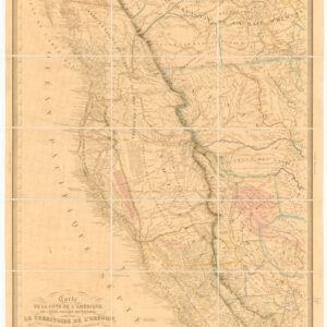
Carte de la Cote de L’Amérique sur l’Océan Pacifique Septentrional le Territoire de l’Orégon, les Californies, la Mer Vermeille, Partie des Territoires de la Compagnie de la Baie d’Hudson, et de l’Amérique Russe.
- $15,000
- Landmark map of the American West by Duflot de Mofras, with period annotations.
-
-
-
-
-
Add to cart
- Asia, Arabia and the Red Sea, Rare Maps of Curiosities - Miscellanea
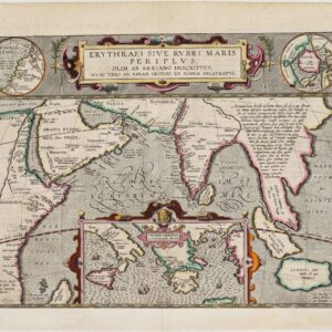
Erythraei Sive Rubri Maris Periplus, olim ab Arriano descriptus, nunc vero ab Abrah. Orelio ex eodem delineatus
- $1,200
- Illustrating a mysterious ancient text: fascinating Ortelius map mixing classical mythology and contemporary exploration.
-
-
-
-
-
-
Add to cart

- Texas and The West
Map of a Reconnoissance between Fort Leavenworth on the Missouri River, and the Great Salt Lake in the Territory Of Utah…
- $650
- One of the seminal cartographic achievements for the mapping of the West, professionally backed on sturdy linen.
-
-
-
-
-
Add to cart
- Texas and The West
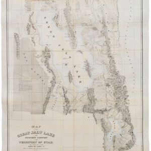
Map of the Great Salt Lake And Adjacent Country in the Territory Of Utah. Surveyed in 1849 and 1850…
- $850
- "Scientific cartography of the Territory of Utah may be said to date from the appearance of this map." - Wheat
-
-
-
-
-
Add to cart
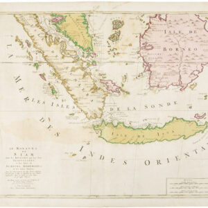
- Asia
Le Royaume de Siam avec les Royaumes qui luy sont Tributaires…
- $525
- Gorgeous Dutch map of the southern Malay peninsula, Sumatra, Borneo, and Java.
-
-
-
-
Add to cart
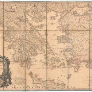
- Greece & the Balkans
Greece Archipelago and part of Anadoli. By L.S. de la Rochette. MDCCXC. London, Published for Willm. Faden, Geographer to the King. January 1st. 1791
- $500
- Large, detailed 1791 map of Greece and Asia Minor with striking cartouche.
-
-