-
-
Add to cart
![[Great Game] Map of Aderbeijan compiled principally from personal observations and surveys made in the years 1851-55 by N. Khanikof…](https://neatlinemaps.com/wp-content/uploads/2024/05/NL-01994_thumbnail-300x300.jpg) Quick View
Quick View - Iran - Persia - Central Asia
[Great Game] Map of Aderbeijan compiled principally from personal observations and surveys made in the years 1851-55 by N. Khanikof…
- $1,800
- Russian Orientalist Nikolai Khanykov’s map of Greater Azerbaijan.
-
-
-
-
Add to cart
 Quick View
 - Americas, Canada and The Great Lakes
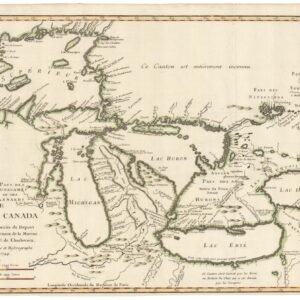
Carte des Lacs du Canada Dresse sur les Manuscrits du Depost des Carts, Plans et Journaux de la Marine et sur le Journal de RP. De Charlevoix.
- A cornerstone map for the cartography of the Great Lakes.
-
-
-
-
Add to cart
 Quick View
 - World
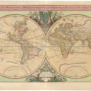
Mappe-Monde Geo-Hydrographique, ou Description Generale du Globe Terrestre et Aquatique en Deux Plans-Hemispheres ou Sont Exactement Remarquees en General Toutes Les Parties De La Terre et de L’Eau, Suivant les Relations Les Plus Nouvelles.
- $4,500
- Jaillot’s famous double-hemisphere in original color and with gold highlights.
-
-
-
-
Add to cart
![[Arctic Exploration] Nord Polar Karte von V. v. Haardt.](https://neatlinemaps.com/wp-content/uploads/2024/05/NL-02108_thumbnail-300x300.jpg) Quick View
Quick View - Polar - Arctic
[Arctic Exploration] Nord Polar Karte von V. v. Haardt.
- $12,500
- The last great map of the North Pole before it was reached.
-
-
-
-
Add to cart
 Quick View
 - Bay Area & Silicon Valley, California
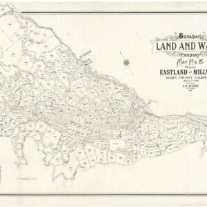
Tamalpais Land and Water Company Map No. 5 showing Eastland and Millwood, Marin County, California.
- $2,800
- Early pre-Mill Valley cadastral map of Eastland and Millwood, Marin County.
-
-
-
-
Add to cart
 Quick View
 - Eastern Mediterranean - Holy Land
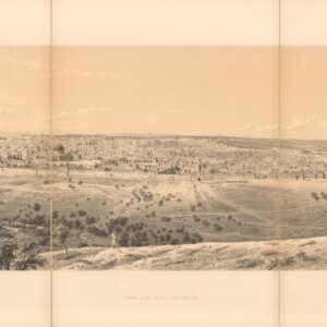
Panorama of Jerusalem, seen from the Mount of Olives.
- $575
- A fantastic mid-19th-century panoramic view of Jerusalem.
-
-
-
-
Add to cart
 Quick View
 - Atlases & Books, World
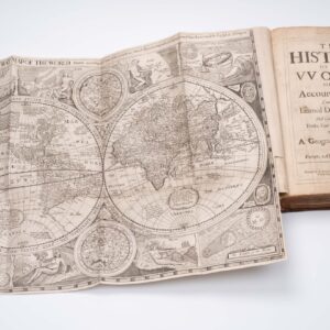
The history of the vvorld: or, An account of time. Compiled by the learned Dionisius Petavius. And continued by others, to the year of our Lord, 1659. Together with a geographicall description of Europe, Asia, Africa, and America.
- $9,500
- With Robert Walton's rare world map.
-
-
-
-
Add to cart
![[Carl Borg Oil Painting] “Spring Day, California.”](https://neatlinemaps.com/wp-content/uploads/2024/05/NL-02101_thumbnail-300x300.jpg) Quick View
Quick View - California
[Carl Borg Oil Painting] “Spring Day, California.”
- $24,000
- A rare modernist painting of the Santa Barbara Hills.
-
-
-
-
Add to cart
![[With Independent Texas] Mappemonde en deux hémisphères.](https://neatlinemaps.com/wp-content/uploads/2024/05/NL-02089_thumbnail-300x300.jpg) Quick View
Quick View - World
[With Independent Texas] Mappemonde en deux hémisphères.
- $600
- A definitive overview of world geography at the dawn of the Victorian Age.
-
-
-
-
Add to cart
 Quick View
 - Atlases & Books, California, San Francisco
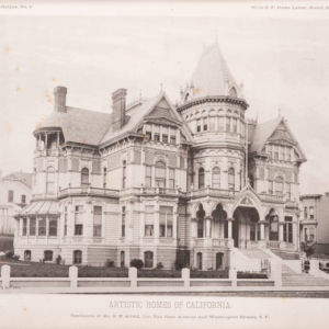
Artistic Homes of California.
- $12,500
- The most extensive collection of pre-1906 Bay Area architectural masterpieces.
-
-
-
-
Add to cart
 Quick View
 - Americas, Mexico - Central & South America
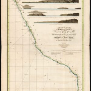
Spherical chart of part of the coast of Peru, from the Parallel of 7.° to 21.° 45.’ South Latititude; Surveyed and Drawn by Order of the King of Spain in the year 1790, By Officers of the Royal Navy.
- $950
- The best coastal view of Peru in the early 19th century.
-
-
-
-
Add to cart
 Quick View
 - Atlases & Books, California, Texas and The West
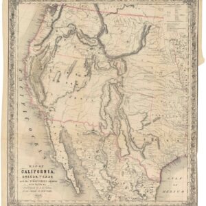
Map of California, Oregon, Texas, and the territories adjoining, with routes &c.
- $1,900
- Colton’s iconic map of the West, with California Gold region and extended Texas borders.
-
-